| East Fork Arkansas River[1] | |
|---|---|
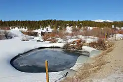 The East Fork just after it goes under County Road 9 and just before it merges with Tennessee Creek to form the Arkansas River. | |
| Physical characteristics | |
| Source | |
| • location | Mosquito Range |
| • coordinates | 39°19′38″N 106°09′56″W / 39.32722°N 106.16556°W |
| • elevation | 13,200 ft (4,000 m) |
| Mouth | |
• location | Confluence with Arkansas |
• coordinates | 39°15′25″N 106°20′38″W / 39.25694°N 106.34389°W |
• elevation | 9,728 ft (2,965 m) |
| Basin features | |
| Progression | Arkansas—Mississippi |
East Fork Arkansas River is a 20.6-mile-long (33.2 km)[2] tributary of the Arkansas River that flows from a source on Mount Arkansas in the Mosquito Range of central Colorado. It joins with Tennessee Creek to form the Arkansas River west of Leadville, Colorado.
See also
References
- ↑ "East Fork Arkansas River". Geographic Names Information System. United States Geological Survey, United States Department of the Interior. Retrieved 2011-01-30.
- ↑ U.S. Geological Survey. National Hydrography Dataset high-resolution flowline data. The National Map Archived 2012-03-29 at the Wayback Machine, accessed March 31, 2011
This article is issued from Wikipedia. The text is licensed under Creative Commons - Attribution - Sharealike. Additional terms may apply for the media files.