 Dennis shortly before making a second landfall in Cuba | |
| Meteorological history | |
|---|---|
| Duration | July 8—9, 2005 |
| Category 4 hurricane | |
| 1-minute sustained (SSHWS/NWS) | |
| Highest winds | 140 mph (220 km/h) |
| Lowest pressure | 941 mbar (hPa); 27.79 inHg |
| Overall effects | |
| Fatalities | 16 |
| Damage | $1.4 billion (2005 USD) |
| Areas affected | Cuba |
Part of the 2005 Atlantic hurricane season | |
| History
Effects Other wikis | |
The effects of Hurricane Dennis in Cuba were deadly and damaging. On July 8, after rapidly intensifying, Hurricane Dennis made landfall in Cuba, first in Puerto Del Ingles as a 140 mph (230 km/h) and then again at winds of 140 mph (230 km/h), this time in Punta Mangles Altos.
Background

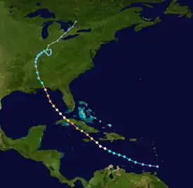
Tropical storm (39–73 mph, 63–118 km/h)
Category 1 (74–95 mph, 119–153 km/h)
Category 2 (96–110 mph, 154–177 km/h)
Category 3 (111–129 mph, 178–208 km/h)
Category 4 (130–156 mph, 209–251 km/h)
Category 5 (≥157 mph, ≥252 km/h)
Unknown
Dennis was formed by a tropical wave that moved off the coast of Africa on June 29. By July 2, it was organizing and on July 4, it formed as a tropical depression. It then turned west-northwest and strengthened into a tropical storm on July 5, and a hurricane on July 7. After that, it rapidly intensified into a Category 4 hurricane before making landfall near Punta Del Ingles, Cuba on July 8. While crossing southeast Cuba, it weakened to a Category 3, before restrengthening as it reached the Gulf of Guacanayabo into a Category 4. It reached a peak intensity of 150 mph (240 km/h) before weakening into a 140 mph (230 km/h) storm at landfall in Punta Mangles Altos, Cuba later also on July 8. After that, the storm traversed most of western Cuba, before emerging into the Gulf of Mexico near Havana, Cuba with winds of 85 mph (137 km/h) on July 9.
The storm went through a period of gradual intensification before once again going through rapid intensification in the Gulf of Mexico. It reached a third peak intensity of 145 mph (233 km/h). However, the storm soon weakened after dry air reached into the storm. It later made landfall on Santa Rosa Island, Florida, with winds of 120 mph (190 km/h) and a pressure of 946 mbar (27.9 inHg) on July 10. It rode across the Florida Panhandle as a hurricane before weakening to a tropical storm by the time it reached southwestern Alabama. By the time it reached east-central Mississippi, it weakened to a tropical depression. It turned northeastward and moved into the Ohio Valley, where it weakened into a low-pressure system. It then accelerated northeastward and eventually got absorbed into a larger low pressure system over northwestern Ontario.[1]
Preparations
In preparation of the storm, over 1,500,000 Cubans were forced to leave their homes, 130,000 being students and 17,000 being foreign tourists.[2] Around 1,000 food preparing centers were stocked and 1,800 evacuation centers were activated. 140,000 people worked in life prevention and evacuation activities while 1,600 civil defense units were activated.[3] The United Nations sent officials to Cuba to be on standby before the storm arrived.[4]
Impact
Over 120,000 houses were damaged in some sort of way; 15,000 had collapsed, 25,000 had been partially destroyed, 24,000 had lost their roofs, and 60,000 had some sort of roof damage. Most of the damaged houses were in the southeastern provinces of Cuba, however, many houses that had been damaged did have some sort of a structural deficiency. Several health units in the country were damaged due to high winds and rain. Floods contaminated running water; 70% of water sources in Granma alone were contaminated. To prevent the damage of electric generation stations, most were forced to halt, causing a complete failure of the countries electrical system. More than 1,000 poles were downed across the country and more than 21 counties in Cuba were still without power on July 11. Communications were also cut; in Matanzas and Cienfuegos provinces alone, 14 communication towers were down. Many roads were also blocked by things such as trees, fallen power lines, and mudslides. In Cienfuegos and Granma, almost 27,000 hectares of agriculture land was reportedly destroyed by the storm.[3] Of the deaths, 13 of them occurred in Granma.[5] The storm dumped up to 27.67 inches (70.3 cm) of rain.[6]
Aftermath
Many families who lost their homes were forced to stay in schools that had been closed for summer break. Medical teams and clean-up brigades were formed to help the injured and clean up fallen trees and debris. Two and a half million people were left without running water, instead relying on water tankers to bring them water.[3] America sent 100,00$ to the World Food Programme (WFP) to feed people in Granma. Japan later extended this to give enough money for 191 tons of rice.[7] The United States offered $50,000 in aid, but Fidel Castro rejected the aid, stating he would never accept aid from the United States until the economic sanctions and embargoes, in place since 1959, were dropped.[5]
References
- ↑ Beven, Jack (November 22, 2005). "Tropical Cyclone Report Hurricane Dennis July 4-13 2004" (PDF). NHC. Retrieved April 18, 2022.
- ↑ "Hurricane Dennis kills 10 in Cuba". BBC. July 9, 2005. Retrieved April 18, 2022.
- 1 2 3 "Caribbean:Hurricane Dennis OCHA Situation Report No. 7". reliefweb. July 13, 2005. Retrieved April 18, 2022.
- ↑ "UN puts disaster teams on standby as Hurricane Dennis roars through Caribbean". UN News. 2005-07-08. Retrieved 2023-01-12.
- 1 2 "Hurricane Dennis killed 16 in Cuba - Castro". reliefweb.int. July 12, 2005. Retrieved 2023-01-12.
- ↑ "Dennis Comparable to Major Hurricanes Ivan, Katrina". WeatherBug. August 13, 2015.
- ↑ "Humanitarian Assistance to Cuba through WFP". reliefweb. September 16, 2005. Retrieved April 18, 2022.