Eldred, Kansas | |
|---|---|
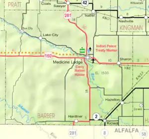 KDOT map of Barber County (legend) | |
 Eldred  Eldred | |
| Coordinates: 37°03′02″N 98°46′04″W / 37.05056°N 98.76778°W[1] | |
| Country | United States |
| State | Kansas |
| County | Barber |
| Elevation | 1,667 ft (508 m) |
| Time zone | UTC-6 (CST) |
| • Summer (DST) | UTC-5 (CDT) |
| Area code | 620 |
| FIPS code | 20-20110 [1] |
| GNIS ID | 484525 [1] |
Eldred is an unincorporated community in Barber County, Kansas, United States.[1] It is 7 miles (11 km) northwest of Hardtner.
History
The post office in Eldred was discontinued in 1908.[2]
References
- 1 2 3 4 5 "Eldred, Kansas", Geographic Names Information System, United States Geological Survey, United States Department of the Interior
- ↑ "Kansas Post Offices, 1828-1961". Kansas Historical Society. Archived from the original on October 9, 2013. Retrieved June 18, 2014.
Further reading
External links
Municipalities and communities of Barber County, Kansas, United States | ||
|---|---|---|
| Cities | 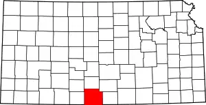 Map of Kansas highlighting Barber County | |
| Unincorporated communities | ||
| Townships | ||
| Footnotes | †This community is designated a Census-Designated Place (CDP) by the United States Census Bureau. | |
This article is issued from Wikipedia. The text is licensed under Creative Commons - Attribution - Sharealike. Additional terms may apply for the media files.