Farafangana | |
|---|---|
City & district | |
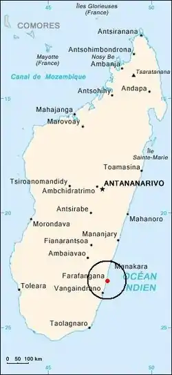 Location of Farafangana | |
| Coordinates: 22°48′05″S 47°35′54″E / 22.8015°S 47.59827°E | |
| Country | Madagascar |
| Region | Atsimo-Atsinanana |
| Area | |
| • Total | 4,763 km2 (1,839 sq mi) |
| Elevation | 1 m (3 ft) |
| Time zone | UTC+3 (EAT) |
| postal code | 309 |
| Climate | Af |
| Website | www |
Farafangana is a district of Atsimo-Atsinanana in Madagascar.[2][3]
Communes
The district is further divided into 30 communes:
- Ambalatany
- Ambalavato
- Ambohigogo
- Ambohimandroso
- Amporoforo
- Ankarana Miraihina
- Anosivelo
- Anosy Tsararafa
- Antsiranambe
- Beretra Bevoay
- Efatsy Anandroza
- Etrotroka Sud
- Evato
- Farafangana
- Fenoarivo
- Iabohazo
- Ihorombe
- Ivandrika
- Mahabo Mananivo
- Mahafasa Centre
- Mahavelo
- Maheriraty
- Manambotra Sud
- Marovandrika
- Sahamadio
- Tangainony
- Tovona
- Vohilengo
- Vohimasy
- Vohitromby
Economy
There is an airport in Farafangana (Farafangana Airport). One of the main crops in the region is pepper.[4]
Population
Natives are mainly from ethnic groups Antefasy, Rabakara, Antesaka and Zafisoro.
Education
Farafangana has a university.[5]
Tourism
The Manombo Reserve is located at 25 km to Farafangana.[6]
See also
References
- ↑ <COMMUNE RURALE DE MAHAVELO ET FOKONTANY MAROPANAHY, DISTRICT DE FARAFANGANA, REGION ATSIMO ATSINANANA
- ↑ REPOBLIKAN’I MADAGASIKARA:Tanindrazana – Fahafahana – Fandrosoana (PDF). MINISTERE DE L’AGRICULTURE, DE L’ELEVAGE ET DE LA PECHE. October 2007. pp. 42–44. Archived from the original (PDF) on 2018-06-12. Retrieved 2018-06-09.
- ↑ "Madagascar: Administrative Division". citypopulation. Retrieved 10 June 2018.
- ↑ (in French) www.commerce.gov.mg Archived 2013-03-24 at the Wayback Machine
- ↑ centre universitaire à Farafangana
- ↑ "travalmadagascar.org". Archived from the original on 2020-03-27. Retrieved 2022-06-12.
Capital: Farafangana | ||
| Befotaka Sud (6) - 307 | 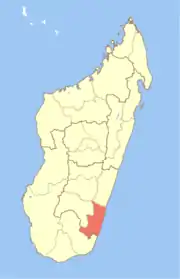 | |
| Farafangana (30) - 309 |
| |
| Midongy-Atsimo (6) - 318 | ||
| Vangaindrano (28) - 320 | ||
| Vondrozo (16) - 322 | ||
5 districts; 86 communes | ||
This article is issued from Wikipedia. The text is licensed under Creative Commons - Attribution - Sharealike. Additional terms may apply for the media files.