Faridan County
Persian: شهرستان فریدن | |
|---|---|
County | |
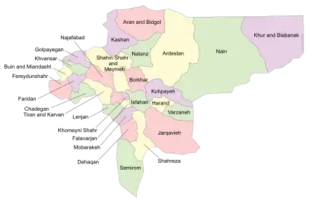 Location of Faridan County in Isfahan province (left, purple) | |
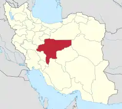 Location of Isfahan province in Iran | |
| Coordinates: 32°57′N 50°26′E / 32.950°N 50.433°E[1] | |
| Country | |
| Province | Isfahan |
| Capital | Daran |
| Districts | Central, Zendeh Rud |
| Population (2016)[2] | |
| • Total | 49,890 |
| Time zone | UTC+3:30 (IRST) |
| Faridan County can be found at GEOnet Names Server, at this link, by opening the Advanced Search box, entering "9205992" in the "Unique Feature Id" form, and clicking on "Search Database". | |
Faridan County (Persian: شهرستان فریدن) is in Isfahan province, Iran. Its capital is the city of Daran.
At the 2006 census, the county's population was 81,622 in 20,215 households.[3] The following census in 2011 counted 79,743 people in 22,770 households.[4] At the 2016 census, the county's population was 49,890 in 15,547 households,[2] by which time Buin Miandasht District had been separated from the county in the establishment of Buin Miandasht County.[5]
Administrative divisions
The population history and structural changes of Faridan County's administrative divisions over three consecutive censuses are shown in the following table. The latest census shows two districts, five rural districts, and two cities.[2]
| Administrative Divisions | 2006[3] | 2011[4] | 2016[2] |
|---|---|---|---|
| Central District | 54,036 | 53,606 | 38,538 |
| Dalankuh RD | 3,971 | 4,252 | 3,697 |
| Varzaq RD | 13,055 | 12,532 | |
| Varzaq-e Jonubi RD | 8,862 | 8,043 | 6,539 |
| Zayandeh Rud-e Shomali RD | 4,705 | 4,517 | 3,858 |
| Damaneh (city) | 4,513 | 4,617 | 4,366 |
| Daran (city) | 18,930 | 19,645 | 20,078 |
| Buin Miandasht District1 | 27,586 | 26,137 | |
| Gorji RD | 606 | 526 | |
| Karchambu-e Jonubi RD | 2,425 | 2,019 | |
| Karchambu-e Shomali RD | 3,293 | 2,446 | |
| Sardsir RD | 3,512 | 2,838 | |
| Yeylaq RD | 4,012 | 3,739 | |
| Afus (city) | 3,805 | 4,313 | |
| Buin Miandasht (city) | 9,933 | 10,256 | |
| Zendeh Rud District | 11,270 | ||
| Qarah Bisheh RD | 9,638 | ||
| Varzaq RD | 1,632 | ||
| Total | 81,622 | 79,743 | 49,890 |
| RD: Rural District 1Became a part of Buin Miandasht County[5] | |||
Wikimedia Commons has media related to Faridan County.
References
- ↑ OpenStreetMap contributors (12 June 2023). "Faridan County" (Map). OpenStreetMap. Retrieved 12 June 2023.
- 1 2 3 4 "Census of the Islamic Republic of Iran, 1395 (2016)". AMAR (in Persian). The Statistical Center of Iran. p. 10. Archived from the original (Excel) on 19 October 2020. Retrieved 19 December 2022.
- 1 2 "Census of the Islamic Republic of Iran, 1385 (2006)". AMAR (in Persian). The Statistical Center of Iran. p. 10. Archived from the original (Excel) on 20 September 2011. Retrieved 25 September 2022.
- 1 2 "Census of the Islamic Republic of Iran, 1390 (2011)" (Excel). Iran Data Portal (in Persian). The Statistical Center of Iran. p. 10. Retrieved 19 December 2022.
- 1 2 Rahimi, Mohammad Reza (7 May 2013). "Six new cities and towns were added to the map of country divisions, with some changes in the geography of the seven provinces of the country". DOLAT (in Persian). Ministry of Interior, Board of Ministers. Archived from the original on 14 July 2014. Retrieved 12 June 2023.

| Capital | |||||||||||||||
|---|---|---|---|---|---|---|---|---|---|---|---|---|---|---|---|
| Districts |
| ||||||||||||||
This article is issued from Wikipedia. The text is licensed under Creative Commons - Attribution - Sharealike. Additional terms may apply for the media files.