Fernwood, Idaho | |
|---|---|
Town | |
 Fernwood in North Idaho | |
| Coordinates: 47°06′44″N 116°23′34″W / 47.11222°N 116.39278°W | |
| Country | United States |
| State | Idaho |
| County | Benewah |
| Elevation | 2,733 ft (833 m) |
| Population (2000) | |
| • Total | 684 |
| Time zone | UTC-8 (Pacific Time Zone) |
| • Summer (DST) | UTC-7 |
| ZIP code | 83830 |
| Area code | 208 |
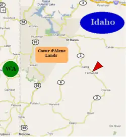
Fernwood is a small unincorporated community in the southeastern corner of Benewah County, Idaho, United States, located just to the east of State Highway 3. The city shares a public K-6 school with the communities of Clarkia, Santa and Emida. All students attend high school and middle school in St. Maries.[2]
The 2000 census recorded a population of 684[3] with an average household income of $27,578. The median age in the tabulation area is 41.2 and the average household size is 2.51.[4]
History
.jpg.webp)
Logging near Fernwood ca. 1910
The Coeur d’Alene people initially inhabited this area for thousands of years prior to the coming of white settlers. The native name of the area is Epschssups'n or “It has a little tail.”[5]
Fernwood's population was estimated at 250 in 1960.[6]
References
- ↑ U.S. Geological Survey Geographic Names Information System: USGS Place names
- ↑ Upriver School District #41, District website, archived from the original on July 18, 2011, retrieved March 17, 2007
{{citation}}: CS1 maint: numeric names: authors list (link) - ↑ The figure represents the entire area of Fernwood-Santa-Emida ZCTA and not the actual population of the city.
- ↑ United States Census Bureau (2000), 2000 Census of Population, archived from the original on February 12, 2020, retrieved March 17, 2007
- ↑ Coeur d'Alene Tribe GIS Program
- ↑ World Book Encyclopedia. Vol. I. Field Enterprises Corporation. 1960. p. 27.
Municipalities and communities of Benewah County, Idaho, United States | ||
|---|---|---|
| Cities | Map of Idaho highlighting Benewah County | |
| CDPs | ||
| Other unincorporated communities | ||
| Indian reservation | ||
| Footnotes | ‡This populated place also has portions in an adjacent county or counties | |
This article is issued from Wikipedia. The text is licensed under Creative Commons - Attribution - Sharealike. Additional terms may apply for the media files.