Filiatra
Φιλιατρά | |
|---|---|
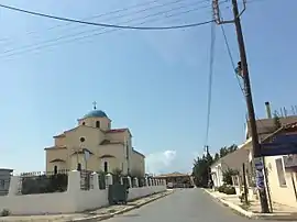
 Street with St Charalampos church | |
 Filiatra Location within the regional unit  | |
| Coordinates: 37°9′N 21°35′E / 37.150°N 21.583°E | |
| Country | Greece |
| Administrative region | Peloponnese |
| Regional unit | Messenia |
| Municipality | Trifylia |
| • Municipal unit | 114.9 km2 (44.4 sq mi) |
| Elevation | 66 m (217 ft) |
| Population (2011)[1] | |
| • Municipal unit | 7,514 |
| • Municipal unit density | 65/km2 (170/sq mi) |
| Community | |
| • Population | 6,791 (2011) |
| Time zone | UTC+2 (EET) |
| • Summer (DST) | UTC+3 (EEST) |
| Postal code | 243 00 |
| Area code(s) | 27610 |
| Vehicle registration | ΚΜ |
| Website | filiatra.gr |
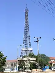
Filiatra (Greek: Φιλιατρά), is a town and a former municipality in Messenia, Peloponnese, Greece. Since the 2011 local government reform it is part of the municipality Trifylia, of which it is a municipal unit.[2] The municipal unit has an area of 114.877 km2.[3] Filiatra is situated near the Ionian Sea coast in western Messenia. It is located 11 km northwest of Gargalianoi, 13 km southwest of Kyparissia, 29 km northwest of Pylos and 49 km west of Kalamata. The Greek National Road 9 (Patras - Pyrgos - Kyparissia - Pylos) passes through the town. Filiatra was founded around the 12th and the 13th centuries. It was built near the site of the ancient city Erana. Filiatra has several schools, churches and shops. A scaled reproduction of the Eiffel Tower stands at the entrance to the village. The local soccer club is Erani Filiatra.

Subdivisions
The municipal unit Filiatra is subdivided into the following communities (2011 population in brackets):
The community Filiatra consists of the following settlements, besides the Filiatra town proper:
- Agia Kyriaki
- Agrilos
- Kountri
- Lagkouvardos - a beach area located near Agia Kyriaki
- Lempestena
- Limenari, the access from Filiatra to the sea. It is around 2 km from the town centre
- Merolithi
- Stomio
- Vryses
Historical population
| Year | Town | Community | Municipal unit |
|---|---|---|---|
| 1981 | 5,139 | - | - |
| 1991 | 6,062 | 7,753 | - |
| 2001 | 6,719 | 7,882 | 9,334 |
| 2011 | 5,969 | 6,791 | 7,514 |
Notable people
- The Liberopoulos brothers:
- Nikos Liberopoulos, soccer player
- Sotiris Liberopoulos, soccer player
- Nikolaos Frousos, soccer player
- Pavlos Dionysopoulos, artist
- Theodoros Marangos, Film Director
See also
References
- 1 2 "Απογραφή Πληθυσμού - Κατοικιών 2011. ΜΟΝΙΜΟΣ Πληθυσμός" (in Greek). Hellenic Statistical Authority.
- ↑ "ΦΕΚ B 1292/2010, Kallikratis reform municipalities" (in Greek). Government Gazette.
- ↑ "Population & housing census 2001 (incl. area and average elevation)" (PDF) (in Greek). National Statistical Service of Greece. Archived from the original (PDF) on 2015-09-21.
External links
- Municipal website (in Greek)
- Municipality of Filiatra Internet Portal (in Greek)
- Filiatra Forum (in Greek)
- Filiatra
- Pirsos
- Fykia Lyceum/Middle School (in Greek)
- Erani Sporting Club (in Greek)