Floridablanca | |
|---|---|
| Municipality of Floridablanca | |
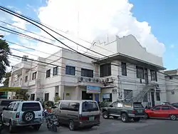 Municipal Hall | |
 Flag  Seal | |
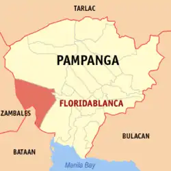 Map of Pampanga with Floridablanca highlighted | |
OpenStreetMap | |
.svg.png.webp) Floridablanca Location within the Philippines | |
| Coordinates: 14°58′26″N 120°31′41″E / 14.974°N 120.528°E | |
| Country | Philippines |
| Region | Central Luzon |
| Province | Pampanga |
| District | 2nd district |
| Founded | April 30, 1867 |
| Barangays | 33 (see Barangays) |
| Government | |
| • Type | Sangguniang Bayan |
| • Mayor | Darwin R. Manalansan |
| • Vice Mayor | Michael L. Galang |
| • Representative | Gloria Macapagal Arroyo |
| • Municipal Council | Members |
| • Electorate | 72,707 voters (2022) |
| Area | |
| • Total | 175.48 km2 (67.75 sq mi) |
| Elevation | 28 m (92 ft) |
| Highest elevation | 114 m (374 ft) |
| Lowest elevation | 7 m (23 ft) |
| Population (2020 census)[3] | |
| • Total | 135,542 |
| • Density | 770/km2 (2,000/sq mi) |
| • Households | 30,994 |
| Economy | |
| • Income class | 1st municipal income class |
| • Poverty incidence | 2.92 |
| • Revenue | ₱ 404.7 million (2020) |
| • Assets | ₱ 531.6 million (2020) |
| • Expenditure | ₱ 355.6 million (2020) |
| • Liabilities | ₱ 183.6 million (2020) |
| Service provider | |
| • Electricity | San Fernando Electric Light and Power Company (SFELAPCO) |
| Time zone | UTC+8 (PST) |
| ZIP code | 2006 |
| PSGC | |
| IDD : area code | +63 (0)45 |
| Native languages | Kapampangan Tagalog |
Floridablanca, officially the Municipality of Floridablanca (Kapampangan: Balen ning Floridablanca; Filipino: Bayan ng Floridablanca) is a 1st class municipality in the province of Pampanga, Philippines. According to the 2020 census, it has a population of 135,542 people.[3] Floridablanca is a part of the province of the Pampanga located in Central Luzon lying north of Dinalupihan, Bataan and south-southwest of San Fernando, Pampanga.
Etymology
Floridablanca is derived from Spanish which translates to "white flower." However, there are two versions of the name's origin:[5]
- in honor of José Moñino, 1st Count of Floridablanca, a former chief minister of Spain whom the locals believed to have visited the place in the early 1800s despite the lack of evidence of his visit; or
- white flowers of a pandacaqui plant (Tabernaemontana pandacaqui) that flourished in the town, considered as a more credible origin.
Previously, the town was named San Jose de Calampaui, which is derived from Spanish for Saint Joseph, its patron saint.
History

Floridablanca was founded in 1823 as Hacienda de San Jose de Calampaui at the site of a monastery. In 1867, it was renamed to Pueblo de Floridablanca.
In the 1920s, the Pampanga Sugar Mill was built at Del Carmen in the 1920s. The area was the site of military bases of the Philippine Commonwealth Army and the Philippine Constabulary from 1942 to 1946. The Philippine Air Force established Basa Air Base at a former American military airfield in 1947.[5]
Geography
Floridablanca is located on the western part of Pampanga along the Zambales mountain ranges and is bounded by the municipalities of Porac on the north, Lubao on the south, Guagua on the east, and Dinalupihan, Bataan on the west. It is 40 kilometers (25 mi) from the city of San Fernando and 106 kilometers (66 mi) from Manila. The town is at an elevation of 12 feet (3.7 m) above sea level. Floridablanca is north of Dinalupihan, Bataan via Dinalupihan-Floridablanca Access Road at the Bataan-Pampanga boundary line.
With an area of 17,548 hectares (43,360 acres), it is the third largest municipality in the province, after Porac and Candaba.
Barangays
Floridablanca is politically subdivided into 33 barangays. Each barangay consists of puroks and some have sitios.
- Anon
- Apalit
- Basa Air Base
- Benedicto
- Bodega
- Cabangcalan
- Calantas
- Carmencita
- Consuelo
- Culubasa
- Dampe
- Del Carmen
- Fortuna
- Gutad
- Mabical
- Maligaya
- Mawacat
- Nabuclod
- Pabanlag
- Paguiruan
- Palmayo
- Pandaguirig
- Poblacion
- San Antonio
- San Isidro
- San Jose
- San Nicolas
- San Pedro
- San Ramon
- San Roque
- Santa Monica
- Solib
- Santo Rosario
- Valdez
Climate
| Climate data for Floridablanca, Pampanga | |||||||||||||
|---|---|---|---|---|---|---|---|---|---|---|---|---|---|
| Month | Jan | Feb | Mar | Apr | May | Jun | Jul | Aug | Sep | Oct | Nov | Dec | Year |
| Mean daily maximum °C (°F) | 30 (86) |
31 (88) |
33 (91) |
34 (93) |
33 (91) |
31 (88) |
29 (84) |
29 (84) |
29 (84) |
30 (86) |
31 (88) |
30 (86) |
31 (87) |
| Mean daily minimum °C (°F) | 19 (66) |
19 (66) |
20 (68) |
23 (73) |
25 (77) |
25 (77) |
24 (75) |
24 (75) |
24 (75) |
23 (73) |
21 (70) |
20 (68) |
22 (72) |
| Average precipitation mm (inches) | 8 (0.3) |
9 (0.4) |
15 (0.6) |
34 (1.3) |
138 (5.4) |
203 (8.0) |
242 (9.5) |
233 (9.2) |
201 (7.9) |
126 (5.0) |
50 (2.0) |
21 (0.8) |
1,280 (50.4) |
| Average rainy days | 3.7 | 4.1 | 6.5 | 11.2 | 21.2 | 24.9 | 27.7 | 26.5 | 25.5 | 21.8 | 12.6 | 5.6 | 191.3 |
| Source: Meteoblue[6] | |||||||||||||
Demographics
|
| |||||||||||||||||||||||||||||||||||||||||||||||||||
| Source: Philippine Statistics Authority[3][7][8][9][10] | ||||||||||||||||||||||||||||||||||||||||||||||||||||
In the 2020 census, the population of Floridablanca, Pampanga, was 135,542 people,[3] with a density of 770 inhabitants per square kilometer or 2,000 inhabitants per square mile.
Economy
Floridablanca is the second largest producer of rice in the province. It produces more than enough rice to meet its needs resulting in a surplus. In 1999, only 37.76% of its produce was used for its own rice requirement resulting in a surplus of 65.24% equivalent to 17,553 metric tons.
Government
Local government
Like other towns in the Philippines, Floridablanca is governed by a mayor and vice mayor who are elected to three-year terms. The mayor is the executive head and leads the town's departments in executing the ordinances and improving public services. The vice mayor heads a legislative council (Sangguniang Bayan) consisting of councilors from the Barangays of Barrios.
List of municipal leaders
Capitan Municipal
- 1897 – Don Gerónimo Romero Dinio
- 1898 – Don Cecilio Alvendia
- 1899 – Don Alejandro Ramos
Municipal Presidents
- 1900–1902 – Don Gerónimo Romero Dinio
- 1903–1905 – Don Alejandro Ramos
- 1906–1908 – Don Gregorio Panlaqui
- 1909–1911 – Don León Gutiérrez
- 1911 – Don Arcadio Ramírez
- 1912–1917 – Don Martin Sundiam
- 1918–1922 – Don José O. Dinio
- 1923–1925 – Don Isidoro Alvendia
- 1926–1931 – Don Roberto Nuguid
- 1932–1937 – Don Camilo Ocampo
Municipal Mayors
- 1938–1940 – Geronimo Dinio Coronel
- 1941 – Benigno Layug
- 1942–1943 – Francisco Vargas
- 1943–1944 – Fidel Pekson
- 1944 – Leandro Garcia
- 1945 – Benigno Layug
- 1945 – Dr. Vicente Chincuanco
- 1945–1946 – Mariano Macabulos
- 1946–1947 – Arsenio T. Isip
- 1948–1951 – Mariano Macabulos
- 1951–1955 – Dominador Diyco Songco
- 1956–1959 – Atty. Marcelo Dungca Mendiola
- 1960–1967 – Dominador Diyco Songco
- 1968–1971 – Jose Dungca Mendiola
- 1972–1986 – Pedro Manuel Capulong
- 1986–1992 – Tito Morales Mendiola
- 1992–2001 – Pedro Manuel Capulong
- 2001–2004 – Joerey Montemayor
- 2004–2007 – Darwin Manalansan
- 2007–2016 – Eduardo Guerrero
- 2016–present – Darwin Manalansan
Tourism
Aside from Basa Air Base, the town has cultural treasures and interesting points.
- 1887 San Jose Obrero Parish Church: the Roman Catholic Archdiocese of San Fernando exercises jurisdiction over the Heritage Church.
- Bahay na Puti (Alvendia House): the Justice Carmelino Alvendia, Sr. ancestral mansion is owned, preserved and maintained by his family.
Notable personalities
- Dante Rivero, movie actor
- Jillian Ward, actress
- Justice Carmelino Alvendia, Sr.
- Rhea Santos, newsreader from GMA and OMNI
Gallery
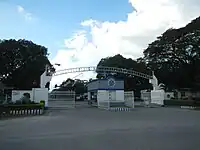 Basa Air Base Main Gate
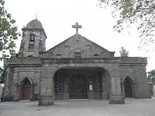 Façade of the Saint Joseph the Worker Parish Church
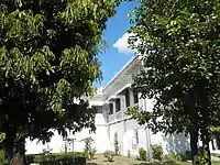 The heritage house of the town
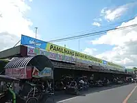 Public market
References
- ↑ Municipality of Floridablanca | (DILG)
- ↑ "2015 Census of Population, Report No. 3 – Population, Land Area, and Population Density" (PDF). Philippine Statistics Authority. Quezon City, Philippines. August 2016. ISSN 0117-1453. Archived (PDF) from the original on May 25, 2021. Retrieved July 16, 2021.
- 1 2 3 4 Census of Population (2020). "Region III (Central Luzon)". Total Population by Province, City, Municipality and Barangay. Philippine Statistics Authority. Retrieved July 8, 2021.
- ↑ "PSA Releases the 2018 Municipal and City Level Poverty Estimates". Philippine Statistics Authority. December 15, 2021. Retrieved January 22, 2022.
- 1 2 "History of Floridablanca". Municipality of Floridablanca, Province of Pampanga – Abe abe king panyulung. Retrieved July 18, 2023.
- ↑ "Floridablanca: Average Temperatures and Rainfall". Meteoblue. Retrieved May 5, 2020.
- ↑ Census of Population (2015). "Region III (Central Luzon)". Total Population by Province, City, Municipality and Barangay. Philippine Statistics Authority. Retrieved June 20, 2016.
- ↑ Census of Population and Housing (2010). "Region III (Central Luzon)" (PDF). Total Population by Province, City, Municipality and Barangay. National Statistics Office. Retrieved June 29, 2016.
- ↑ Censuses of Population (1903–2007). "Region III (Central Luzon)". Table 1. Population Enumerated in Various Censuses by Province/Highly Urbanized City: 1903 to 2007. National Statistics Office.
{{cite encyclopedia}}: CS1 maint: numeric names: authors list (link) - ↑ "Province of". Municipality Population Data. Local Water Utilities Administration Research Division. Retrieved December 17, 2016.
- ↑ "Poverty incidence (PI):". Philippine Statistics Authority. Retrieved December 28, 2020.
- ↑ "Estimation of Local Poverty in the Philippines" (PDF). Philippine Statistics Authority. November 29, 2005.
- ↑ "2003 City and Municipal Level Poverty Estimates" (PDF). Philippine Statistics Authority. March 23, 2009.
- ↑ "City and Municipal Level Poverty Estimates; 2006 and 2009" (PDF). Philippine Statistics Authority. August 3, 2012.
- ↑ "2012 Municipal and City Level Poverty Estimates" (PDF). Philippine Statistics Authority. May 31, 2016.
- ↑ "Municipal and City Level Small Area Poverty Estimates; 2009, 2012 and 2015". Philippine Statistics Authority. July 10, 2019.
- ↑ "PSA Releases the 2018 Municipal and City Level Poverty Estimates". Philippine Statistics Authority. December 15, 2021. Retrieved January 22, 2022.