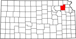
Franklin Township | |
|---|---|
 Location in Jackson County | |
| Coordinates: 39°26′00″N 95°44′21″W / 39.43333°N 95.73917°W | |
| Country | United States |
| State | Kansas |
| County | Jackson |
| Area | |
| • Total | 33.43 sq mi (86.57 km2) |
| • Land | 32.33 sq mi (83.73 km2) |
| • Water | 1.1 sq mi (2.84 km2) 3.28% |
| Elevation | 1,125 ft (343 m) |
| Population (2000) | |
| • Total | 776 |
| • Density | 24/sq mi (9.3/km2) |
| GNIS feature ID | 0478189 |
Franklin Township is a township in Jackson County, Kansas, USA. As of the 2000 census, its population was 776. The southwesternmost part of the township is located within the Prairie Band Potawatomi Indian Reservation.
History
Franklin Township was formed in 1856.[1] It was named for Ben Franklin.[2]
Geography
Franklin Township covers an area of 33.43 square miles (86.57 square kilometers); of this, 1.1 square miles (2.84 square kilometers) or 3.28 percent is water. The stream of Banner Creek runs through this township.
Unincorporated towns
(This list is based on USGS data and may include former settlements.)
Adjacent townships
- Liberty Township (north)
- Straight Creek Township (northeast)
- Garfield Township (east)
- Cedar Township (southeast)
- Lincoln Township (southwest)
- Banner Township (west)
- Jefferson Township (northwest)
Cemeteries
The township contains two cemeteries: Bruck and Holton.
Major highways
References
- ↑ Barr, Elizabeth N. (1907). Business directory and history of Jackson County. p. 13.
- ↑ Barr, Elizabeth N. (1907). Business directory and history of Jackson County. p. 33.
External links
This article is issued from Wikipedia. The text is licensed under Creative Commons - Attribution - Sharealike. Additional terms may apply for the media files.
