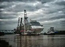

The Friesenbrücke is a railway bridge in Weener, Germany, crossing the river Ems.
Background
The first bridge was built under the name Emsbrücke Hilkenborg between 1874 and 1876.[1] In June 1922 the lighter Hohenfelde, towed by the Theseus, collided with the bridge, making the construction of a new bridge necessary.[2]
Between 1924 and 1926 the new bridge, a bascule bridge and the first Friesenbrücke, was built with a length of about 335 meters. During World War 2 it was blown up by German soldiers (Wehrmacht) to stop the Canadian soldiers at the Ems.[2]
After World War 2, a new Friesenbrücke was built between 1951 and 1952, also a bascule bridge.[2] The bridge wasn't wide enough to allow all newbuilts of the Meyer Werft in Papenburg to pass the bridge since the 1980s, so a second was created, which was opened by a crane vessel multiple times a year.
In December 2015 the bridge was damaged by the cargo ship Emsmoon. Since then, the bridge has been closed. The bridge was demolished in 2021/22.
A new Friesenbrücke is planned to be completed in 2024 as a swing bridge.[3][4] Construction officially started in July 2021.[5]
References
- ↑ Schenkelberg: Die Friesenbrücke über die Ems bei Weener. In: Zentralblatt der Bauverwaltung, 46. Jahrgang 1926, Nr. 47 (vom 24. November 1926), S. 530–533 (vgl. Literatur).
- 1 2 3 "Oldenburg – Leer – Nieuweschans → Strecken & Stationen → Emsbrücke Hilkenborg" (in German). Retrieved 2022-03-06.
- ↑ "Friesenbrücke - Europas größte Hub-Dreh-Brücke" [Friesenbrücke - Europe's largest lifting and rotating bridge] (in German). Deutsche Bahn. 16 March 2022. Retrieved 21 April 2023.
- ↑ "Europas größte Hub-Dreh-Brücke entsteht: Deutsche Bahn baut neue Friesenbrücke" [Europe's largest lifting and rotating bridge is being built: Deutsche Bahn is building a new Frisian bridge] (in German). Deutsche Bahn. 23 July 2021. Retrieved 21 April 2023.
- ↑ "Weener: Symbolischer Baustart für die neue Friesenbrücke". 2021-07-23. Retrieved 2023-08-22.