Fryšták | |
|---|---|
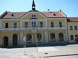 Town hall | |
 Flag  Coat of arms | |
 Fryšták Location in the Czech Republic | |
| Coordinates: 49°17′6″N 17°41′3″E / 49.28500°N 17.68417°E | |
| Country | |
| Region | Zlín |
| District | Zlín |
| First mentioned | 1356 |
| Government | |
| • Mayor | Pavel Gálík |
| Area | |
| • Total | 24.17 km2 (9.33 sq mi) |
| Elevation | 271 m (889 ft) |
| Population (2023-01-01)[1] | |
| • Total | 3,800 |
| • Density | 160/km2 (410/sq mi) |
| Time zone | UTC+1 (CET) |
| • Summer (DST) | UTC+2 (CEST) |
| Postal code | 763 16 |
| Website | www |
Fryšták (German: Freistadtl) is a town in Zlín District in the Zlín Region of the Czech Republic. It has about 3,800 inhabitants. The historic town centre is well preserved and is protected by law as an urban monument zone.
Administrative parts
.jpg.webp)
Villages of Dolní Ves, Horní Ves and Vítová are administrative parts of Fryšták.
Geography
Fryšták is located about 5 kilometres (3 mi) north of Zlín. The northern part of the municipal territory lies in the Hostýn-Vsetín Mountains, rest of the territory lies in the Vizovice Highlands. The highest point is at 566 m (1,857 ft) above sea level. Fryšták lies on the border between ethnographic regions of Moravian Wallachia and Hanakia.
The town is situated lies on the Fryštácký Stream. The Fryšták Reservoir was built on this stream in 1935–1938 as a water source for Zlín. Since 1997, the reservoir has been protected as a cultural monument.[2]
History
The first written mention of Fryšták is from 15 January 1356 under its Latin name Freystat. In 1382, Fryšták was described as a prosperous town with trade, crafts, a slaughterhouse and a spa. The prosperity was interrupted by the Thirty Years' War.[3]
By the 19th century, Fryšták was notable for agriculture and wood production. The fire of 1841 caused Fryšták's traditional wooden buildings to be replaced by more modern buildings. By the latter 20th century a contemporary wave of building with construction of many new houses included the installation of modern infrastructure such as natural gas lines and telephone networks.[3]
Demographics
|
|
| ||||||||||||||||||||||||||||||||||||||||||||||||||||||
| Source: Censuses[4][5] | ||||||||||||||||||||||||||||||||||||||||||||||||||||||||
Sights
.JPG.webp)
The landmark of the town is the Church of Saint Nicholas. The building is not architecturally clean, it can best be described as a baroque building. The original part of the church is from the 16th century, in 1820 the building was extended and the bell tower was replaced by a new one. The baroque stone cross in front of the church is from 1763.[6]
The first stone town hall was built in Fryšták in 1680. The old building was replaced by a new one in 1900.[7]
Notable people
- Jaroslav Kvapil (1892–1958), composer, conductor and pianist
- Břetislav Bakala (1897–1958), conductor, pianist and composer
- Václav Renč (1911–1973), poet, dramatist and translator; lived here
- Dalibor Brázda (1921–2005), Czech-Swiss composer, arranger and conductor
Twin towns – sister cities
References
- ↑ "Population of Municipalities – 1 January 2023". Czech Statistical Office. 2023-05-23.
- ↑ "Přehrada Fryšták u Zlína" (in Czech). CzechTourism. Retrieved 2022-01-02.
- 1 2 "Historie města" (in Czech). Město Fryšták. Retrieved 2022-01-02.
- ↑ "Historický lexikon obcí České republiky 1869–2011 – Okres Zlín" (in Czech). Czech Statistical Office. 2015-12-21. pp. 1–2.
- ↑ "Population Census 2021: Population by sex". Public Database. Czech Statistical Office. 2021-03-27.
- ↑ "Historie" (in Czech). Farnost Fryšták. Retrieved 2022-01-02.
- ↑ "Fryštácká radnice po 100 letech září opět historickou novotou" (in Czech). Město Fryšták. Retrieved 2022-01-02.
- ↑ "Partnerská města" (in Czech). Město Fryšták. Retrieved 2022-01-02.