The Frying Pan Shoals are a shifting area of shoals off Cape Fear in North Carolina, United States. Formed by silt from the Cape Fear River, the shoals are over 28 miles long and resemble a frying pan in shape.[1] They provide excellent fishing.[2][3]
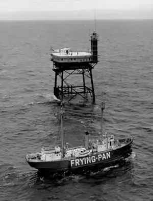
The shoals are known for the high number of shipwrecks found in the region and are deemed part of the Graveyard of the Atlantic.[4] From May 1994 to August 2008, over 130 new shipwreck locations have been discovered in the area. Known since the beginning of European exploration, the shoals were marked on a map in 1738. The southern edge of the shoals has been marked by nine lightships including the Frying Pan, a light tower, and a weather buoy. The Bald Head Light and the Oak Island lighthouse have also provided warning to mariners.
External links
References
- ↑ Steelman, Ben (July 8, 2009). "What are Frying Pan Shoals?". Wilmington Star News. Retrieved 2021-12-20.
- ↑ Disalver, Jerry. "Grouper fishing is world-class at Frying Pan Shoals". carolinasportsman.com. Retrieved 2021-12-20.
- ↑ Disalver, Jerry. "Offshore fishing cranks up south and east of Cape Fear in April". northcarolinasportsman.com. Retrieved 2021-12-20.
- ↑ Wright, Pam (September 17, 2018). "Frying Pan Tower Owner Hopes American Flag Ripped to Shreds By Florence Will Inspire People to Act". The Weather Channel. Retrieved 2019-04-11.