Gianyar Regency
Kabupaten Gianyarᬓᬩᬸᬧᬢᬾᬦ᭄ᬕᬶᬳᬜᬃ | |
|---|---|
.jpg.webp) A library building in Gianyar | |
 Seal | |
| Motto: Dharma Raksata Raksita | |
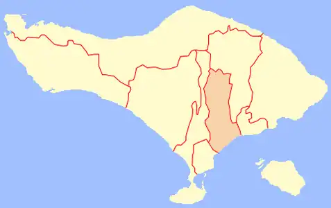 Location within Bali | |
| Coordinates: 8°32′38.76″S 115°19′31.66″E / 8.5441000°S 115.3254611°E | |
| Country | |
| Province | |
| Capital | Gianyar |
| Government | |
| • Regent | Anak Agung Gde Agung Bharata |
| Area | |
| • Total | 368.00 km2 (142.09 sq mi) |
| Population (mid 2022 estimate)[1] | |
| • Total | 523,972 |
| • Density | 1,400/km2 (3,700/sq mi) |
| Time zone | UTC+8 (ICST) |
| Area code | (+62) 361 |
| Website | gianyarkab.go.id |
Gianyar Regency is a regency (kabupaten) in the Indonesian province and island of Bali, Indonesia. It has an area of 368.0 km2 and had a population of 469,777 at the 2010 Census,[2] and 515,344 at the 2020 Census,[3] making it the second most densely populated district in Bali (after Badung);[4] the official estimate as of mid-2022 was 523,973 - comprising 262,708 males and 261,264 females.[1] Its regency seat is the town of Gianyar. The civil registry survey of April 2011 listed 480,447 people, of which 469,929 were classified as Hindu.[5]
The town of Ubud, a centre of art and tourism, is located in Gianyar Regency.
Rajas of Gianyar
- Ida Anak Agung Gde Agung (1921–1999)
Condotels and Apartments ban
Although Badung Regency, Denpasar City, and Gianyar Regency are the three richest regions in Bali and most of their wealth comes from tourism, in February 2012 Gianyar Regency officially banned the construction of new and increasingly popular condominium hotels ("condotels") and apartment facilities. Unlike the Badung Regency and Denpasar, where condotels and apartments remain in high demand for tourist developers and investors, Gianyar Regency wants to protect local entrepreneurs.[6]
Administrative districts
The regency is divided into seven districts (kecamatan), tabulated below with their areas and population totals from the 2010 Census[2] and the 2020 Census,[3] together with the official estimates as at mid-2022.[1] The table also includes the number of administrative villages in each district (a total of 64 rural desa and 6 urban kelurahan), and its postal codes. The administrative centre of each district bears the same name as the district it is in.
| Kode Wilayah | Name of District (kecamatan) | Area in km2 | Pop'n Census 2010 | Pop'n Census 2020 | Pop'n Estimate mid 2022 | No. of villages | Post codes |
|---|---|---|---|---|---|---|---|
| 51.04.01 | Sukawati | 55.02 | 110,429 | 119,975 | 121,700 | 12 | 80582 |
| 51.04.02 | Blahbatuh | 39.70 | 65,875 | 74,093 | 75,700 | 9 | 80581 |
| 51.04.03 | Gianyar (town) | 50.59 | 86,843 | 101,444 | 104,400 | 17 (a) | 80511 - 90515 |
| 51.04.04 | Tampaksiring | 42.63 | 45,818 | 50,864 | 51,800 | 8 | 80552 |
| 51.04.05 | Ubud | 42.38 | 69,323 | 71,568 | 71,900 | 8 (b) | 80571 |
| 51.04.06 | Tegallalang | 61.80 | 50,325 | 52,257 | 52,600 | 7 | 80561 |
| 51.04.07 | Payangan | 75.88 | 41,164 | 45,143 | 45,900 | 9 | 80572 |
| Totals | 368.00 | 469,777 | 515,344 | 523,972 | 70 |
Notes: (a) comprises 5 kelurahan and 12 desa. (b) including one kelurahan - the town of Ubud.
The four southern districts (Sukawati, Blahbatuh, Gianyar, and Ubud) are included within the official metropolitan area of Greater Denpasar (Sarbagita), while the three northern districts (Tampaksiring, Tegallalang, and Payangan) are excluded.
Religion
The civil registry survey of April 2011 listed 480,447 people, of which 469,929 were classified as Hindu.[7]
- Map of Gianyar Regency in Bali
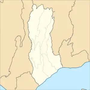 Map of districts in Gianyar Regency
List of districts and villages in Gianyar Regency as follows:
| Code | Districts | Urban villages | Rural Villages | Status | List |
|---|---|---|---|---|---|
| 51.04.02 | Blahbatuh | - | 9 | Desa |
|
| 51.04.03 | Gianyar | 5 | 12 | Desa |
|
| Kelurahan |
| ||||
| 51.04.07 | Payangan | - | 9 | Desa |
|
| 51.04.01 | Sukawati | - | 12 | Desa |
|
| 51.04.04 | Tampaksiring | - | 8 | Desa |
|
| 51.04.06 | Tegallalang | - | 7 | Desa |
|
| 51.04.05 | Ubud | 1 | 7 | Desa |
|
| Kelurahan |
| ||||
| TOTAL | 6 | 64 |
Keramas Beach
Keramas Beach in Blahbatuh has hosted international surfing competitions in the last couple of years with limited facilities such as uneven roads and no parking lots. On June 18–29, 2013, Keramas Beach was on the Association of Surfing Professionals (ASP)'s 2013 Men's World Championship Tour schedule as the Oakley Bali Pro.[8][9]
Sports

In football, Bali is home to the football club Bali United, which plays in the Liga 1. The team was relocated from Samarinda, East Kalimantan, to Gianyar, Bali. Harbiansyah Hanafiah, the main commissioner of Bali United, explained that he did the name change and moved the home to Bali because there were no representatives from Bali in the highest football tier in Indonesia.[10] Another reason was that local fans in Samarinda preferred to support Pusamania Borneo F.C. more than Persisam.
Climate
Gianyar has a tropical rainforest climate (Af) with moderate to heavy rainfall year-round. The following climate data is for the town of Gianyar.
| Climate data for Gianyar | |||||||||||||
|---|---|---|---|---|---|---|---|---|---|---|---|---|---|
| Month | Jan | Feb | Mar | Apr | May | Jun | Jul | Aug | Sep | Oct | Nov | Dec | Year |
| Mean daily maximum °C (°F) | 30.3 (86.5) |
30.5 (86.9) |
30.6 (87.1) |
31.1 (88.0) |
30.8 (87.4) |
30.0 (86.0) |
29.3 (84.7) |
29.6 (85.3) |
30.3 (86.5) |
31.0 (87.8) |
31.1 (88.0) |
30.7 (87.3) |
30.4 (86.8) |
| Daily mean °C (°F) | 26.4 (79.5) |
26.5 (79.7) |
26.4 (79.5) |
26.4 (79.5) |
26.1 (79.0) |
25.2 (77.4) |
24.8 (76.6) |
25.0 (77.0) |
25.7 (78.3) |
26.4 (79.5) |
26.6 (79.9) |
26.5 (79.7) |
26.0 (78.8) |
| Mean daily minimum °C (°F) | 22.5 (72.5) |
22.5 (72.5) |
22.2 (72.0) |
21.7 (71.1) |
21.4 (70.5) |
20.5 (68.9) |
20.4 (68.7) |
20.5 (68.9) |
21.1 (70.0) |
21.8 (71.2) |
22.2 (72.0) |
22.3 (72.1) |
21.6 (70.9) |
| Average rainfall mm (inches) | 276 (10.9) |
265 (10.4) |
172 (6.8) |
84 (3.3) |
114 (4.5) |
134 (5.3) |
186 (7.3) |
95 (3.7) |
112 (4.4) |
152 (6.0) |
164 (6.5) |
251 (9.9) |
2,005 (79) |
| Source: Climate-Data.org[11] | |||||||||||||
Education
- Yayasan Slukat Learning Center (2007), a non-profit foundation and school located in the village of Keramas
References
- 1 2 3 Badan Pusat Statistik, Jakarta, 2023, Kabupaten Gianyar Dalam Angka 2023 (Katalog-BPS 1102001.5104)
- 1 2 Biro Pusat Statistik, Jakarta, 2011.
- 1 2 Badan Pusat Statistik, Jakarta, 2021.
- ↑ Vickers (1995)
- ↑ "Dinas Kependudukan & Catatan Sipil Kab. Gianyar". Archived from the original on 2012-11-11. Retrieved 2012-11-24.
- ↑ "Gianyar bans new condotels, apartments". February 17, 2012.
- ↑ "Dinas Kependudukan & Catatan Sipil Kab. Gianyar". Archived from the original on 2012-11-11. Retrieved 2012-11-24.
- ↑ "Better facilities required for Keramas Beach". June 7, 2013. Archived from the original on October 6, 2013.
- ↑ "2013 Oakley Bali Pro". World Surf League. June 2013. Retrieved December 12, 2015.
- ↑ "Putra Samarinda Berubah Jadi Bali United Pusam". Retrieved 14 April 2017.
- ↑ "Climate: Gianyar". Climate-Data.org. Retrieved 17 November 2020.
Further reading
- Vickers, Adrian (1995), Gianyar Regency. taken from Oey, Eric, ed. (1995). Bali. Singapore: Periplus Editions. p. 115. ISBN 962-593-028-0.
External links
 Media related to Gianyar Regency at Wikimedia Commons
 Central Bali travel guide from Wikivoyage
- (in Indonesian) Official website