Greymouth Central | |
|---|---|
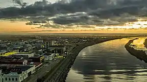 Greymouth viewed from the north-east | |
| Country | New Zealand |
| City | Greymouth |
| Local authority | Grey District Council |
| Electoral ward | Central |
| Area | |
| • Land | 357 ha (882 acres) |
| Population (June 2022)[2] | |
| • Total | 2,020 |
| Airports | Greymouth Airport |
| Blaketown | Cobden | |
| (Tasman Sea) |
|
|
| Karoro | Wharemoa |
Greymouth Central is the central business district of Greymouth on the West Coast of New Zealand, which also contains residential housing.
The earliest street names honour pioneer residents, explorers and prominent local Māori, while others pay tribute to English literary figures and politicians. Later developments recognise the achievements of local residents who contributed significantly to civic and local body affairs.[3]
Demographics
Greymouth Central covers 3.57 km2 (1.38 sq mi)[1] and had an estimated population of 2,020 as of June 2022,[2] with a population density of 566 people per km2.
| Year | Pop. | ±% p.a. |
|---|---|---|
| 2006 | 2,400 | — |
| 2013 | 2,136 | −1.65% |
| 2018 | 2,031 | −1.00% |
| Source: [4] | ||
Greymouth Central had a population of 2,031 at the 2018 New Zealand census, a decrease of 105 people (−4.9%) since the 2013 census, and a decrease of 369 people (−15.4%) since the 2006 census. There were 888 households, comprising 954 males and 1,080 females, giving a sex ratio of 0.88 males per female, with 273 people (13.4%) aged under 15 years, 366 (18.0%) aged 15 to 29, 792 (39.0%) aged 30 to 64, and 597 (29.4%) aged 65 or older.
Ethnicities were 87.7% European/Pākehā, 9.0% Māori, 1.8% Pasifika, 6.9% Asian, and 2.4% other ethnicities. People may identify with more than one ethnicity.
The percentage of people born overseas was 14.0, compared with 27.1% nationally.
Although some people chose not to answer the census's question about religious affiliation, 45.2% had no religion, 42.4% were Christian, 0.1% had Māori religious beliefs, 1.2% were Hindu, 0.3% were Muslim and 1.5% had other religions.
Of those at least 15 years old, 222 (12.6%) people had a bachelor's or higher degree, and 492 (28.0%) people had no formal qualifications. 177 people (10.1%) earned over $70,000 compared to 17.2% nationally. The employment status of those at least 15 was that 732 (41.6%) people were employed full-time, 255 (14.5%) were part-time, and 42 (2.4%) were unemployed.[4]
| Name | Area (km2) | Population | Density (per km2) | Households | Median age | Median income |
|---|---|---|---|---|---|---|
| Greymouth Central | 2.73 | 978 | 358 | 402 | 52.7 years | $23,900[5] |
| King Park | 0.84 | 1,053 | 1,254 | 486 | 45.1 years | $24,800[6] |
| New Zealand | 37.4 years | $31,800 |
Education

There are four schools in the central Greymouth area, and other schools in the suburbs or adjoining areas of Blaketown, Cobden and Karoro.
Greymouth High School is a secondary (years 9–13) school with a roll of 606.[7]
Greymouth Main School is a full primary (years 1–8) school with a roll of 247.[8]
John Paul II High School is a secondary (years 9–13) school with a roll of 166.[9] The school was formed in 1980 from the merger of Marist Brothers Boys’ School and St Mary’s High School.[10]
St Patrick's School is a full primary (years 1–8) school with a roll of 169.[11] Both are state integrated Catholic schools. The schools are adjacent to each other and have a shared Board of Trustees.[12][13]
All these schools are co-educational. Rolls are as of April 2023.[14]
There is also a tertiary provider. Tai Poutini Polytechnic has its head office based in Greymouth. It also has campuses in Auckland, Christchurch, Hokitika, Reefton, Wanaka and Westport.
References
- 1 2 "ArcGIS Web Application". statsnz.maps.arcgis.com. Retrieved 4 August 2023.
- 1 2 "Population estimate tables - NZ.Stat". Statistics New Zealand. Retrieved 25 October 2022.
- ↑ Buckley, Frances (2004). Greymouth street names: a short history (2 ed.). Greymouth: Grey District Library. ISBN 0-476-00294-X.
- 1 2 "Statistical area 1 dataset for 2018 Census". Statistics New Zealand. March 2020. Greymouth Central (310300) and King Park (310400).
- ↑ 2018 Census place summary: Greymouth Central
- ↑ 2018 Census place summary: King Park
- ↑ Education Counts: Greymouth High School
- ↑ Education Counts: Greymouth Main School
- ↑ Education Counts: John Paul II High School
- ↑ "Description of the School". John Paul II High School.
- ↑ Education Counts: St Patrick's School, Greymouth
- ↑ "Education Review Report: John Paul II High School". Education Review Office. August 2007.
- ↑ "Education Review Report: St Patrick's School Greymouth". Education Review Office. August 2006.
- ↑ "New Zealand Schools Directory". New Zealand Ministry of Education. Retrieved 12 December 2022.