Griebelschied | |
|---|---|
 Coat of arms | |
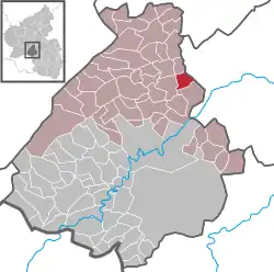
Location of Griebelschied within Birkenfeld district  | |
 Griebelschied  Griebelschied | |
| Coordinates: 49°48′04″N 07°24′01″E / 49.80111°N 7.40028°E | |
| Country | Germany |
| State | Rhineland-Palatinate |
| District | Birkenfeld |
| Municipal assoc. | Herrstein-Rhaunen |
| Government | |
| • Mayor (2019–24) | Markus Hey[1] |
| Area | |
| • Total | 4.19 km2 (1.62 sq mi) |
| Elevation | 397 m (1,302 ft) |
| Population (2021-12-31)[2] | |
| • Total | 181 |
| • Density | 43/km2 (110/sq mi) |
| Time zone | UTC+01:00 (CET) |
| • Summer (DST) | UTC+02:00 (CEST) |
| Postal codes | 55608 |
| Dialling codes | 06752 |
| Vehicle registration | BIR |
| Website | www.griebelschied.de |
Griebelschied is an Ortsgemeinde – a municipality belonging to a Verbandsgemeinde, a kind of collective municipality – in the Birkenfeld district in Rhineland-Palatinate, Germany. It belongs to the Verbandsgemeinde Herrstein-Rhaunen, whose seat is in Herrstein.
Geography
Location
The municipality lies west of the Nahe between Kirn and Herrstein. Forty-three percent of the municipal area is wooded.
History
In 1279, Griebelschied had its first documentary mention. In 1800, Schinderhannes (Johannes Bückler), an infamous outlaw, celebrated his “Robber’s Ball of Griebelschied”.
Politics
Municipal council
The council is made up of 6 council members, who were elected by majority vote at the municipal election held on 7 June 2009, and the honorary mayor as chairman.[3]
Mayor
Griebelschied's mayor is Markus Hey.[1]
Coat of arms
The municipality's arms might be described thus: Per bend Or a lion rampant gules armed and langued azure, and vert an oakleaf bendwise slipped and a sprig of acorns bendwise sinister, the two per saltire in base and the whole of the first.
Culture and sightseeing
The following are listed buildings or sites in Rhineland-Palatinate’s Directory of Cultural Monuments:[4]
- Evangelical church, Hauptstraße – essentially a late mediaeval aisleless church with ridge turret; décor from the 18th century
Economy and infrastructure
To the southeast runs Bundesstraße 41. Available in nearby Kirn is a railway station on the Nahe Valley Railway (Bingen–Saarbrücken).
References
- 1 2 Direktwahlen 2019, Landkreis Birkenfeld, Landeswahlleiter Rheinland-Pfalz, accessed 10 August 2021.
- ↑ "Bevölkerungsstand 2021, Kreise, Gemeinden, Verbandsgemeinden" (in German). Statistisches Landesamt Rheinland-Pfalz. 2022.
- ↑ Kommunalwahl Rheinland-Pfalz 2009, Gemeinderat
- ↑ Directory of Cultural Monuments in Birkenfeld district
External links
- Brief portrait of Griebelschied with film at SWR Fernsehen (in German)
- Municipality’s official webpage (in German)