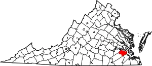
Gwaltney Corner, Virginia | |
|---|---|
Unincorporated community | |
 Gwaltney Corner, Virginia  Gwaltney Corner, Virginia | |
| Coordinates: 37°06′43″N 77°01′26″W / 37.11194°N 77.02389°W | |
| Country | United States |
| State | Virginia |
| County | Surry |
| Elevation | 112 ft (34 m) |
| Time zone | UTC-5 (Eastern (EST)) |
| • Summer (DST) | UTC-4 (EDT) |
| Area code(s) | 757, 948 |
| GNIS feature ID | 1477384[1] |
Gwaltney Corner is an unincorporated community in Surry County, Virginia, United States.[1] Gwaltney Corner is located on Virginia State Route 40, 6.5 miles (10.5 km) northeast of Waverly. Snow Hill, a home which is listed on the National Register of Historic Places, is located near Gwaltney Corner.[2] In 1966, a county dump site was proposed here.[3] There are several hog farms in the area.[4]
References
- 1 2 "Gwaltney Corner". Geographic Names Information System. United States Geological Survey, United States Department of the Interior.
- ↑ "National Register Information System". National Register of Historic Places. National Park Service. July 9, 2010.
- ↑ "Surry Planners Discuss Present, Proposed County Dump Sites". Daily Press. January 26, 1966. p. 16. Retrieved April 11, 2020 – via Newspapers.com.
- ↑ "Board backs hog farms". Daily Press. September 5, 1987. p. 28. Retrieved April 11, 2020 – via Newspapers.com.
This article is issued from Wikipedia. The text is licensed under Creative Commons - Attribution - Sharealike. Additional terms may apply for the media files.
