Harashim | |
|---|---|
 | |
 Harashim | |
| Coordinates: 32°57′23″N 35°19′42″E / 32.95639°N 35.32833°E | |
| Country | Israel |
| District | Northern |
| Council | Misgav |
| Founded | 1980 |
| Population (2021)[1] | 377 |
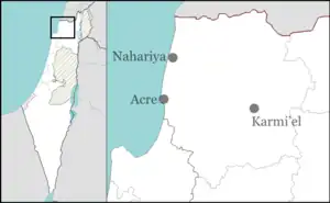
Harashim (Hebrew: חֲרָשִׁים, lit. 'Craftsmen') is a community settlement in northern Israel. Located in the Upper Galilee to the north of Karmiel, it falls under the jurisdiction of Misgav Regional Council. In 2021 it had a population of 377.[1] Its elevation is 830 m (2,723.10 ft).[2] Harashim is the wettest inhabited place in Israel.[3]
History
The village was established in 1980 as part of the Galilee lookout plan to encourage Jewish settlement in the region. Its name is derived from nearby Tel Harashim, an Iron Age Jewish village where it is believed the inhabitants worked as blacksmiths.[4]
Geography
Climate
Harashim has a Mediterranean climate (Köppen climate classification: Csa) with hot, dry summers and cool, rainy and occasionally snowy winters. The village receives 986.8 mm (39 in) of precipitation per year. Summers are rainless and hot with an average high temperature of 29 °C (84 °F) and an average low temperature of 18 °C (64 °F). Winters are cool and wet, and precipitation is occasionally in the form of snow. Winters have an average high temperature of 12 °C (54 °F) and an average low temperature of 5 °C (41 °F). Harashim is the wettest inhabited place in Israel.[3]
| Climate data for Harashim (1991-2020 normals, 1952-2022 extremes) | |||||||||||||
|---|---|---|---|---|---|---|---|---|---|---|---|---|---|
| Month | Jan | Feb | Mar | Apr | May | Jun | Jul | Aug | Sep | Oct | Nov | Dec | Year |
| Record high °C (°F) | 22.0 (71.6) |
24.4 (75.9) |
32.0 (89.6) |
34.1 (93.4) |
36.0 (96.8) |
37.9 (100.2) |
40.0 (104.0) |
39.9 (103.8) |
39.5 (103.1) |
35.0 (95.0) |
29.5 (85.1) |
24.0 (75.2) |
40.0 (104.0) |
| Mean daily maximum °C (°F) | 11.3 (52.3) |
12.4 (54.3) |
15.7 (60.3) |
20.0 (68.0) |
24.6 (76.3) |
27.1 (80.8) |
28.9 (84.0) |
29.3 (84.7) |
27.7 (81.9) |
24.5 (76.1) |
18.5 (65.3) |
13.5 (56.3) |
21.1 (70.0) |
| Daily mean °C (°F) | 8.2 (46.8) |
8.8 (47.8) |
11.3 (52.3) |
14.7 (58.5) |
18.8 (65.8) |
21.5 (70.7) |
23.4 (74.1) |
23.7 (74.7) |
22.1 (71.8) |
19.3 (66.7) |
14.5 (58.1) |
10.3 (50.5) |
16.4 (61.5) |
| Mean daily minimum °C (°F) | 5.0 (41.0) |
5.1 (41.2) |
6.9 (44.4) |
9.5 (49.1) |
13.0 (55.4) |
16.0 (60.8) |
18.0 (64.4) |
18.2 (64.8) |
16.4 (61.5) |
14.1 (57.4) |
10.4 (50.7) |
7.2 (45.0) |
11.6 (53.0) |
| Record low °C (°F) | −5.0 (23.0) |
−5.0 (23.0) |
−0.6 (30.9) |
−2.2 (28.0) |
3.5 (38.3) |
8.6 (47.5) |
12.2 (54.0) |
12.6 (54.7) |
11.0 (51.8) |
4.6 (40.3) |
−0.2 (31.6) |
−2.8 (27.0) |
−5.0 (23.0) |
| Average precipitation mm (inches) | 267 (10.5) |
189 (7.4) |
106 (4.2) |
47 (1.9) |
17.4 (0.69) |
1.7 (0.07) |
0 (0) |
0 (0) |
4.7 (0.19) |
33 (1.3) |
107 (4.2) |
214 (8.4) |
986.8 (38.85) |
| Average precipitation days (≥ 0.1 mm) | 12.5 | 10.3 | 8.0 | 4.3 | 2.1 | 0.5 | 0 | 0 | 0.7 | 3.4 | 6.0 | 10.5 | 58.3 |
| Source: Israel Meteorological Service[5][6] | |||||||||||||
References
- 1 2 "Regional Statistics". Israel Central Bureau of Statistics. Retrieved 22 February 2023.
- ↑ "Harashim". Israel Meteorological Service. Retrieved 6 May 2021.
- 1 2 David Ratner (6 January 2005). "The Wettest Place in Israel". Haaretz. Retrieved 6 May 2021.
- ↑ Jonathan L. Reed (2000). Archaeology and the Galilean Jesus: A Re-examination of the Evidence. Trinity Press International. ISBN 9781563383946. Retrieved 6 May 2021.
- ↑ "Temperature average" (in Hebrew). Israel Meteorological Service. Retrieved 11 December 2011.
- ↑ "Precipitation average" (in Hebrew). Israel Meteorological Service. Retrieved 12 July 2011.