Hematite Township, Michigan | |
|---|---|
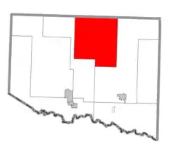 Location within Iron County | |
 Hematite Township Location within the state of Michigan | |
| Coordinates: 46°18′39″N 88°30′21″W / 46.31083°N 88.50583°W | |
| Country | United States |
| State | Michigan |
| County | Iron |
| Area | |
| • Total | 155.8 sq mi (403.4 km2) |
| • Land | 153.5 sq mi (397.4 km2) |
| • Water | 2.3 sq mi (6.0 km2) |
| Elevation | 1,499 ft (457 m) |
| Population (2020) | |
| • Total | 269 |
| • Density | 2.3/sq mi (0.9/km2) |
| Time zone | UTC-6 (Central (CST)) |
| • Summer (DST) | UTC-5 (CDT) |
| FIPS code | 26-37580[1] |
| GNIS feature ID | 1626462[2] |
Hematite Township is a civil township of Iron County in the U.S. state of Michigan. As of the 2000 census, the township population was 352, and by 2020 its population declined to 269.[3] The township is named for the masses of hematite iron ore in the rocks prevalent in the area.
Geography
According to the United States Census Bureau, the township has a total area of 155.8 square miles (404 km2), of which 153.4 square miles (397 km2) is land and 2.3 square miles (6.0 km2) (1.48%) is water.
Communities
- Amasa is an unincorporated community within the township, situated on U.S. Highway 141 at 46°13′58″N 88°26′55″W / 46.23278°N 88.44861°W[4] where it crosses the Hemlock River. It was named for Amasa Stone of Cleveland, Ohio.[5] The ZIP code is 49903.
References
- ↑ "U.S. Census website". United States Census Bureau. Retrieved January 31, 2008.
- ↑ U.S. Geological Survey Geographic Names Information System: Hematite Township, Michigan
- ↑ "Explore Census Data". data.census.gov. Retrieved August 4, 2023.
- ↑ U.S. Geological Survey Geographic Names Information System: Amasa, Michigan
- ↑ Chicago and North Western Railway Company (1908). A History of the Origin of the Place Names Connected with the Chicago & North Western and Chicago, St. Paul, Minneapolis & Omaha Railways. p. 37.
Municipalities and communities of Iron County, Michigan, United States | ||
|---|---|---|
| Cities | 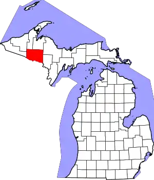 Map of Michigan highlighting Iron County.svg | |
| Villages | ||
| Townships | ||
| CDP | ||
| Other communities | ||
| Defunct | ||
This article is issued from Wikipedia. The text is licensed under Creative Commons - Attribution - Sharealike. Additional terms may apply for the media files.