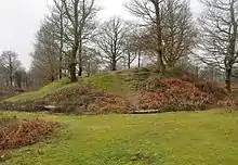
Hembury Castle is an Iron Age hillfort about a mile north-west of the village of Buckfast on the south-eastern edge of Dartmoor in Devon, England (grid reference SX726684). The fort is about 178 metres above sea level on a promontory between the River Dart on the east and the Holy Brook, south-west.[1] The slope down to the River Dart is very steep and is covered by Hembury Woods which is now a Site of Special Scientific Interest.[2]
The fort is said to cover about seven acres and it is surrounded by a prominent rampart and ditch.[1] It is one of several Iron Age forts on the eastern edge of Dartmoor, others include Holne Chase Castle, Wooston Castle, Cranbrook Castle and Prestonbury Castle.[3] Inside the fort, on the western side, is an 11th- or 12th-century motte with a surrounding narrow inner bailey. The ramparts of the earlier hillfort may have been used as the outer bailey of the castle.[4] The entire site has legal protection as a scheduled monument.[5]
The first documentary reference to Hembury Castle is in the 13th-century cartulary of nearby Buckfast Abbey, where it is referred to as vetus castellum quod dicitur Hembire. The name probably derives from Old English hean byrig, "at the high burh".[6]
A legend relates that the fort was held by the Danes, but it was taken from them by a stratagem. Some local women allowed themselves to be captured by the Danes and taken into the fort, but in the night when their captors were in a drunken sleep, the women rose, killed them and let in their countrymen.[1]
References
- 1 2 3 Crossing, William (1976). Crossing's Guide to Dartmoor (Reprint of 1912 ed.). Newton Abbot: David & Charles. p. 350. ISBN 0-7153-4034-4.
- ↑ "Hembury Woods" (PDF). Natural England. Retrieved 18 January 2017.
- ↑ Hemery, Eric (1982). Historic Dart. Newton Abbot: David & Charles. p. 58. ISBN 0-7153-8142-3.
- ↑ Cherry, Bridget; Pevsner, Nikolaus (1989). The Buildings of England: Devon (second ed.). Penguin Books. p. 227. ISBN 0-14-071050-7.
- ↑ "Hembury Castle". Historic England. Retrieved 19 January 2017.
- ↑ Gover, J.E.B., Mawer, A. & Stenton, F.M. (1931). "The Place-Names of Devon". English Place-Name Society. Vol Viii. Part I. Cambridge University Press: 295.
{{cite journal}}: CS1 maint: multiple names: authors list (link)
- Sellman, R.R. (1985). "2: The Iron Age in Devon". Aspects of Devon History. Exeter: Devon Books. p. 11 (Map of Iron Age hill forts in Devon including Hembury Castle). ISBN 0861147561.