Henryków | |
|---|---|
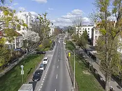
 Malczewskiego Street in Henryków, in 2023. | |
| Coordinates: 52°11′48″N 21°01′31″E / 52.19667°N 21.02528°E | |
| Country | |
| Voivodeship | Masovian |
| City county | Warsaw |
| District | Mokotów |
| City Information System area | Wierzbno |
| Municipal neighbourhood | Wierzbno |
| Time zone | UTC+1 (CET) |
| • Summer (DST) | UTC+2 (CEST) |
| Area code | +48 22 |
Henryków[lower-alpha 1] is a neighbourhood in the city of Warsaw, Poland, in the district of Mokotów.[1] It is located within the City Information System area of Wierzbno, and partially within the municipal neighbourhood of Wierzbno.[2][3] It is a residential area, mostly consisting of villas.[4][5]
Henryków was established in the early 19th century, by Henryk Bonnet, a clerk and a judge. It was originally settled by French people.[6][7] Throughout the 1920s and the 1930s, the neighbourhood went through major development, with villas being constructed within it.[4][5]
History

At the beginning of the 19th century, Henryk Bonnet, a French-born clerk who served as the State Councillor and the judge in the district court of Warsaw, had bought an area around current Malczewskiego Street, establishing there the folwark-type settlement of Henryków. It was originally settled by French people. In there was built a small palace residence of the Bonnet family.[6][7] In 1824, Louisa Bonnet de Belon (1802-1876), Henryk Bonnet's daughter, had married George Fanshawe (1789-1867; also known as Jerzy Fanshave), English-born chamberlain and colonel in the Imperial Russian Army. The couple had inherited the property around 1830.[6][8][9] Around 1850, in place of Bonnet's residence, at current 107A Puławska Street, was built Fanshawe Palace, which became the residence of the Fanshawe family.[10] In 1900, the palace was inherited by nobleman August Potocki, who, while never living there himself, had accommodated there the less wealthy members of his family.[9][11]
From 1867 to 1916, Henryków belonged to the gmina (municipality) of Mokotów. On 8 April 1916, Henryków, together with the rest of its municipality, were incorporated into the city of Warsaw.[12][13]
Between 1920s and 1930s, in area of Henryków were built villas.[4][5]
On 4 October 1996, the district of Mokotów had been subdivided into areas of the City Information System, with Henryków becoming part of the area of Wierzbno.[14]
On 17 July 2014 was established the municipal neighbourhood of Wierzbno, which is governed by the neighbourhood council. It includes western portion of Henryków.[3]
Notes
References
- ↑ Rejestr Nazw Geograficznych – miejscowości – format XLSX, indemnification number: 172643. Warsaw: Główny Urząd Geodezji i Kartografii. 9 August 2022. (in Polish)
- ↑ "Obszary MSI. Dzielnica Mokotów". zdm.waw.pl (in Polish).
- 1 2 "Osiedle Wierzbno". mokotow.um.warszawa.pl (in Polish).
- 1 2 3 Lech Chmielewski: Przewodnik warszawski. Gawęda o nowej Warszawie. Warsaw: Agencja Omnipress. 1987. ISBN 9788385028567. (in Polish).
- 1 2 3 Ula Olczak (7 October 2022). "Wierzbno – mieszkania. Dlaczego warto zamieszkać w tej lokalizacji?". obido.pl (in Polish).
- 1 2 3 B. Petrozolin-Skowrońska (editor): Encyklopedia Warszawy, Warsaw: Polish Scientific Publishers PWN, 1994, p. 245, ISBN 83-01-08836-2. (in Polish).
- 1 2 Teresa Mroczko: Vademecum warszawskie. Warsaw: Wydawnictwo Warszawskiego Tygodnika Ilustrowanego Stolica, 1957, p. 139. (in Polish).
- ↑ Jerzy Majewski: Warszawa nieodbudowana. Królestwo Polskie w latach 1815–1840. Warsaw: Wydawnictwo Veda, 2009, p. 72. ISBN 978-83-61932-00-0. (in Polish).
- 1 2 Juliusz A. Chrościcki, Andrzej Rottermund: Atlas architektury Warszawy. Warsaw: Wydawnictwo Arkady, 1977, p. 185. (in Polish)
- ↑ Marta Leśniakowska: Architektura w Warszawie. Warsaw: Arkada Pracownia Historii Sztuki, 2005, p. 214. ISBN 83-908950-1-3. (in Polish)
- ↑ Jerzy Kasprzycki, Marian Stępień: Pożegnania warszawskie. Warsaw: Arkady, 1971, p. 144. (in Polish)
- ↑ Maria Nietyksza, Witold Pruss: Zmiany w układzie przestrzennym Warszawy. In: Irena Pietrza-Pawłowska (editor): Wielkomiejski rozwój Warszawy do 1918 r.. Warsaw: Wydawnictwo Książka i Wiedza. 1973. p. 43. (in Polish)
- ↑ Postanowienie z 17 [29] września 1866, ogłoszone 5 [17] stycznia 1867. 17 January 1867. In Dziennik Praw 1866 roku, vol. 66, no. 219. p. 276. Warsaw. 1867. (in Polish)
- ↑ Uchwała Nr 389/XXXVI/96 Rady Gminy Warszawa-Centrum w sprawie Miejskiego Systemu Informacyjnego w Gminie Warszawa-Centrum, In: Express Wieczorny, no. 268, 18 November 1996. Warsaw. (in Polish)
