Herndon, Pennsylvania | |
|---|---|
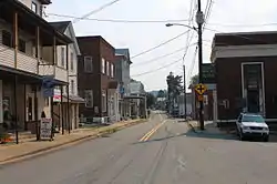
 Main Street (PA 147) in Herndon, September 2015 | |
 Location of Herndon in Northumberland County, Pennsylvania. | |
 Herndon Location on Herndon in Pennsylvania  Herndon Herndon (the United States) | |
| Coordinates: 40°42′15″N 76°50′36″W / 40.70417°N 76.84333°W | |
| Country | United States |
| State | Pennsylvania |
| County | Northumberland |
| Settled | 1827 |
| Incorporated | 1902 |
| Area | |
| • Total | 1.80 sq mi (4.66 km2) |
| • Land | 0.79 sq mi (2.05 km2) |
| • Water | 1.01 sq mi (2.61 km2) |
| Elevation [2] (center of borough) | 440 ft (130 m) |
| Highest elevation [2] (eastern boundary of borough) | 840 ft (260 m) |
| Lowest elevation [2] (Susquehanna River) | 415 ft (126 m) |
| Population | |
| • Total | 347 |
| • Density | 438.69/sq mi (169.36/km2) |
| Time zone | UTC-5 (Eastern (EST)) |
| • Summer (DST) | UTC-4 (EDT) |
| ZIP code | 17830 |
| Area code(s) | 570 and 272 |
| FIPS code | 42-34080 |
Herndon, formerly Trevorton Junction, is a borough along the Susquehanna River in Northumberland County, Pennsylvania, United States. Herndon was first founded by Robert A. Parrish in 1840. The town was later named for Naval commander William Lewis Herndon, who died in 1857 while trying to rescue passengers from his sinking ship.[4] The population was 324 at the 2010 census.
Geography
Herndon is located at 40°42′15″N 76°50′36″W / 40.70417°N 76.84333°W (40.704241, -76.843212).[5]
According to the United States Census Bureau, the borough has a total area of 1.8 square miles (4.7 km2), of which 0.8 square miles (2.1 km2) is land and 1.0 square mile (2.6 km2) (55.06%) is water.
Demographics
| Census | Pop. | Note | %± |
|---|---|---|---|
| 1880 | 306 | — | |
| 1910 | 620 | — | |
| 1920 | 656 | 5.8% | |
| 1930 | 699 | 6.6% | |
| 1940 | 687 | −1.7% | |
| 1950 | 677 | −1.5% | |
| 1960 | 622 | −8.1% | |
| 1970 | 507 | −18.5% | |
| 1980 | 483 | −4.7% | |
| 1990 | 422 | −12.6% | |
| 2000 | 383 | −9.2% | |
| 2010 | 324 | −15.4% | |
| 2020 | 347 | 7.1% | |
| Sources:[6][7][8][3] | |||
At the 2000 census there were 383 people, 173 households, and 106 families residing in the borough. The population density was 477.6 inhabitants per square mile (184.4/km2). There were 192 housing units at an average density of 239.4 per square mile (92.4/km2). The racial makeup of the borough was 97.91% White, 1.83% African American, and 0.26% from two or more races.[7] There were 173 households, 20.2% had children under the age of 18 living with them, 56.1% were married couples living together, 4.0% had a female householder with no husband present, and 38.2% were non-families. 34.7% of households were made up of individuals, and 18.5% were one person aged 65 or older. The average household size was 2.21 and the average family size was 2.83.
In the borough the population was spread out, with 18.5% under the age of 18, 7.0% from 18 to 24, 27.9% from 25 to 44, 24.5% from 45 to 64, and 21.9% 65 or older. The median age was 43 years. For every 100 females, there were 84.1 males. For every 100 females age 18 and over, there were 90.2 males.

The median household income was $37,750 and the median family income was $44,063. Males had a median income of $29,875 versus $17,969 for females. The per capita income for the borough was $23,156. About 5.7% of families and 9.4% of the population were below the poverty line, including 9.1% of those under age 18 and 22.1% of those age 65 or over.
Education
Herndon is served by Line Mountain Jr./Sr. High School.
See also
References
- ↑ "ArcGIS REST Services Directory". United States Census Bureau. Retrieved October 12, 2022.
- 1 2 3 "Herndon Topo Map, Northumberland County PA (Pillow Area)". TopoZone. Locality, LLC. Retrieved 28 November 2019.
- 1 2 "Census Population API". United States Census Bureau. Retrieved Oct 12, 2022.
- ↑ Bell, Herbert C (1993) [1891]. History of Northumberland County. Higginson Book Company. p. 744. ISBN 0-8328-2847-5.
- ↑ "US Gazetteer files: 2010, 2000, and 1990". United States Census Bureau. 2011-02-12. Retrieved 2011-04-23.
- ↑ "Census of Population and Housing". U.S. Census Bureau. Retrieved 11 December 2013.
- 1 2 "U.S. Census website". United States Census Bureau. Retrieved 2008-01-31.
- ↑ "Incorporated Places and Minor Civil Divisions Datasets: Subcounty Resident Population Estimates: April 1, 2010 to July 1, 2012". Population Estimates. U.S. Census Bureau. Archived from the original on 11 June 2013. Retrieved 11 December 2013.
External links
![]() Media related to Herndon, Pennsylvania at Wikimedia Commons
Media related to Herndon, Pennsylvania at Wikimedia Commons
