 | ||||
|---|---|---|---|---|
| Автошлях М20 | ||||
 | ||||
| Route information | ||||
| Part of | ||||
| Length | 28.5 km (17.7 mi) | |||
| Major junctions | ||||
| South end | ||||
| North end | Russian border at Hoptivka checkpoint | |||
| Location | ||||
| Country | Ukraine | |||
| Oblasts | Kharkiv | |||
| Highway system | ||||
| ||||

Hoptivka checkpoint on Ukraine-Russia border
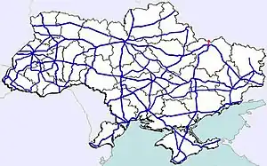
Highway M20 is the second shortest Ukraine international highway (M-highway) which connects Kharkiv to the border with Russia at Hoptivka in Kharkiv Raion in Kharkiv Oblast (Kharkivshchyna) (Ukrainian: Дергачівський район, Ха́рківська о́бласть (Харківщина)) and Nehoteevka in Belgorodsky Raion in Belgorodskaya Oblast (Russian: Нехотеевка, Белгородский район, Белгоро́дская о́бласть).[1] The section from Lisne to the Russian border is part of European route E105, known as the Crimea Highway (Крым шоссе) in Russia.[2]
In 2011, major renovations took place on segments of the road in preparation to the Euro 2012.[3]
Route
| Highway M20 | |||
| Marker | Main settlements | Notes | Highway Interchanges |
|---|---|---|---|
| 0 km | Kharkiv | ||
| 28 km | Hoptivka in Kharkiv Raion / Border (Russia) | ||
See also
References
- ↑ Ukraine International Highways in Russian
- ↑ European Highways in Russian
- ↑ Current renovations of the road are planned to be completed in August. Kharkiv regional administration. 11 July 2011.
External links
- International Roads in Ukraine in Russian
- European Roads in Russian
This article is issued from Wikipedia. The text is licensed under Creative Commons - Attribution - Sharealike. Additional terms may apply for the media files.