Hindisheim
Híndse | |
|---|---|
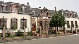 The town hall in Hindisheim | |
 Coat of arms | |
Location of Hindisheim | |
 Hindisheim 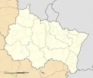 Hindisheim | |
| Coordinates: 48°28′11″N 7°38′23″E / 48.4697°N 7.6397°E | |
| Country | France |
| Region | Grand Est |
| Department | Bas-Rhin |
| Arrondissement | Sélestat-Erstein |
| Canton | Erstein |
| Intercommunality | CC Canton d'Erstein |
| Government | |
| • Mayor (2020–2026) | Pascal Nothisen[1] |
| Area 1 | 11.84 km2 (4.57 sq mi) |
| Population | 1,539 |
| • Density | 130/km2 (340/sq mi) |
| Time zone | UTC+01:00 (CET) |
| • Summer (DST) | UTC+02:00 (CEST) |
| INSEE/Postal code | 67197 /67150 |
| Elevation | 148–154 m (486–505 ft) |
| Website | www |
| 1 French Land Register data, which excludes lakes, ponds, glaciers > 1 km2 (0.386 sq mi or 247 acres) and river estuaries. | |
Hindisheim (French pronunciation: [indisaim]) is a commune in the Bas-Rhin department in Alsace in north-eastern France.[3]
Agriculture retains a leading role in the local economy.
Geography
The village is positioned some twenty kilometres (twelve miles) to the south of Strasbourg, beside the little River Andlau.
Landmarks
- Chapel of the Virgin Mary (fifteenth century). Unusually even in Alsace, this features a half timbered bell tower.
- Church of Saints Peter and Paul (nineteenth century). The church contains a Rinckenbach organ (1922).
See also
References
- ↑ "Répertoire national des élus: les maires" (in French). data.gouv.fr, Plateforme ouverte des données publiques françaises. 13 September 2022.
- ↑ "Populations légales 2021". The National Institute of Statistics and Economic Studies. 28 December 2023.
- ↑ INSEE commune file
External links
Wikimedia Commons has media related to Hindisheim.
This article is issued from Wikipedia. The text is licensed under Creative Commons - Attribution - Sharealike. Additional terms may apply for the media files.