Hingham, Wisconsin | |
|---|---|
Census-designated place | |
 Hingham, Wisconsin | |
| Coordinates: 43°38′20″N 87°54′51″W / 43.63889°N 87.91417°W | |
| Country | United States |
| State | Wisconsin |
| County | Sheboygan |
| Area | |
| • Total | 2.786 sq mi (7.22 km2) |
| • Land | 2.695 sq mi (6.98 km2) |
| • Water | 0.091 sq mi (0.24 km2) |
| Elevation | 804 ft (245 m) |
| Population | |
| • Total | 899 |
| • Density | 320/sq mi (120/km2) |
| Time zone | UTC-6 (Central (CST)) |
| • Summer (DST) | UTC-5 (CDT) |
| ZIP code | 53031 |
| Area code | 920 |
| GNIS feature ID | 1566481[1] |
Hingham is an unincorporated census-designated place located in the town of Lima, in Sheboygan County, Wisconsin, United States, northeast of Adell and southeast of Waldo. It has a post office with ZIP code 53031.[2] As of the 2010 census, its population was 886.[3] The CDP's population rose to 899 at the 2020 census.[4]
History
Hingham was platted on September 5, 1850, by Edward Hobart.[5] The land was acquired from Mrs. David Giddings, who had bought it from the U.S. government in 1846. Streets on the original plat included Water, Center, Spring, South and Main. It was named after Hingham, Massachusetts.[5]
References
- ↑ U.S. Geological Survey Geographic Names Information System: Hingham, Wisconsin
- ↑ ZIP Code Lookup
- ↑ "U.S. Census website". U.S. Census Bureau. Retrieved April 5, 2011.
- ↑ "Total Population in Hingham CDP, Wisconsin is 899" – United States Census Bureau. Retrieved August 28, 2023.
- 1 2 Gustave W. Buchen. Historic Sheboygan County. Sheboygan, Wis.: Author, 1976, pp. 265-266.
Municipalities and communities of Sheboygan County, Wisconsin, United States | ||
|---|---|---|
| Cities | 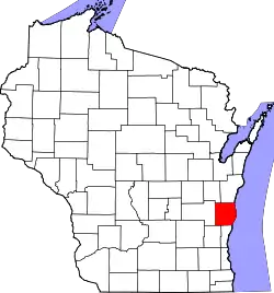 | |
| Villages | ||
| Towns | ||
| CDPs | ||
| Other communities | ||
| Former communities | ||
| Footnotes | ‡This populated place also has portions in an adjacent county or counties | |
This article is issued from Wikipedia. The text is licensed under Creative Commons - Attribution - Sharealike. Additional terms may apply for the media files.