Hrdlív | |
|---|---|
 Municipal office | |
 Flag  Coat of arms | |
 Hrdlív Location in the Czech Republic | |
| Coordinates: 50°11′58″N 14°4′21″E / 50.19944°N 14.07250°E | |
| Country | |
| Region | Central Bohemian |
| District | Kladno |
| First mentioned | 1316 |
| Area | |
| • Total | 1.70 km2 (0.66 sq mi) |
| Elevation | 285 m (935 ft) |
| Population (2023-01-01)[1] | |
| • Total | 514 |
| • Density | 300/km2 (780/sq mi) |
| Time zone | UTC+1 (CET) |
| • Summer (DST) | UTC+2 (CEST) |
| Postal code | 273 06 |
| Website | www |
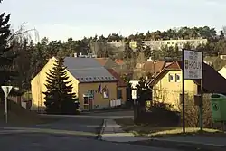
Hrdlív (pronounced [ˈɦr̩dliːf]) is a municipality and village in Kladno District in the Central Bohemian Region of the Czech Republic. It has about 500 inhabitants.
Etymology
The name is derived from the personal name Hrdlej or Hrlej.[2][3]
Geography
Hrdlív is located about 6 kilometres (4 mi) north of Kladno and 23 km (14 mi) northwest of Prague. It lies in the Prague Plateau.
History
.jpg.webp)
The first written mention of Hrdlív is from 1316. From the 15th century, Hrdlív was part of the Smečno estate, which belonged to the Martinic family (since 1792 Clam-Martinic).[2] After the abolition of feudalism in 1848, Hrdlív became part of Třebichovice municipality. In 1906, it became a separate municipality.[3]
Sights
The most notable building is a small Baroque chapel dating from 1745.[2][3]
References
- ↑ "Population of Municipalities – 1 January 2023". Czech Statistical Office. 2023-05-23.
- 1 2 3 "Slánsko" (in Czech). Infocentre Slaný. Retrieved 2022-03-01.
- 1 2 3 "Historie obce" (in Czech). Obec Hrdlív. Retrieved 2022-03-01.