| Ikeda Caldera | |
|---|---|
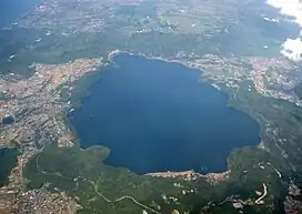
 Lake Ikeda seen from the southeast | |
| Highest point | |
| Peak | Nabeshimadake, 31°13′12″N 130°34′01″E / 31.22°N 130.567°E |
| Elevation | 256 m (840 ft) |
| Coordinates | 31°14′N 130°34′E / 31.24°N 130.56°E[1] |
| Dimensions | |
| Length | 4 km (2.5 mi) NS |
| Width | 5 km (3.1 mi) EW |
| Area | 11 km2 (4.2 sq mi) |
| Naming | |
| Native name | 池田カルデラ (Japanese) |
| Geography | |
| Country | Japan |
| State | Kagoshima Prefecture |
| Region | Ibusuki |
| Geology | |
| Age of rock | from 20,000 years before present[2] |
| Mountain type | Caldera |
| Last eruption | 2,800 years before present[2] |
Ikeda Caldera (池田カルデラ, Ikeda karudera), is a volcanic caldera filled now with Lake Ikeda and associated with the older Ata Caldera on the Satsuma Peninsula.
Geology
The Ikeda volcano produced about 20,000 years before present the Iwamoto tephra layer found right around the region of Kagoshima Bay but not further.[2] It later erupted Senta lava before about 7300 years ago erupting the Kikai-Akahoya tephra.[2] The caldera-forming eruptions began 6400 years ago involving by the time they had finished about 5 km3 (1.2 cu mi) of magma[3] and produced local pyroclastic deposits and the Ikezaki tephra.[2] In subsequent magmatic eruptions fall deposits were created of Osagari and Mizusako scoria and Ikeda pumice.[2] The present caldera was formed 4800 years ago[4] when the Ikeda ignimbrite erupted that reached the eastern and western sides and southern tip of the Satsuma Peninsula. The north western wall of this caldera aligns with the Onkadobira fault scarp.[5] This was followed by later eruptions including the Ikedako tephra and those from a fissure vent line southeast of the caldera that produced the pumiceous Yamagawa base surge.[2] A central lava dome was formed within the caldera during the late stage of these eruptions. About 2,800 years ago on part of the margin of the caldera rim the andesitic[5] Nabeshimadake lava dome was formed.[2] During the caldera forming events, and after, about 2.5 km3 (0.60 cu mi) of ignimbrite and 7 km3 (1.7 cu mi) of tephra was erupted with each of the tephra deposits reaching into the Ōsumi Peninsula due to the prevailing winds.[2]
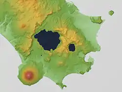
Ikeda Caldera is associated in the Ibusuki volcanic field with the more recently active Kaimondake stratovolcano. The National Catalogue of the Active Volcanoes of Japan (JMA, 2013) includes features of the Ibusuki volcanic field as part of the Ata post-caldera system.[1]


References
- 1 2 "Ata |Global Volcanism Program | Smithsonian Institution". volcano.si.edu. Retrieved 2022-09-19.
- 1 2 3 4 5 6 7 8 9 Inakura, Hirohito; Naruo, Hideto; Okuno, Mitsuru; Kobayashi, Tetsuo (2014). "Eruptive History of Ikeda Volcano, Ibusuki Area, Southern Kyushu, Japan". Bulletin of the Volcanological Society of Japan. 59 (4): 255–268. doi:10.18940/kazan.59.4_255. ISSN 0453-4360.
- ↑ "IAVCEI 2013 Scientific Assembly A Guide for Mid-Conference Field Trip". Retrieved 2022-09-19.
- ↑ Okuno, Mitsuru (2019-04-15). "Chronological study on widespread tephra and volcanic stratigraphy of the past 100,000 years". The Journal of the Geological Society of Japan. 125 (1): 41–53. doi:10.5575/geosoc.2018.0069. ISSN 1349-9963.
- 1 2 Matumoto, Tadaiti (1965-08-28). "Calderas of Kyusyu" (PDF). Transactions of the Luna Geological Field Conference. Retrieved 2022-09-19.
External links
- Quaternary Volcanoes: Ikeda - Geological Survey of Japan
