Zianagar | |
|---|---|
| Indurkani Upazila | |
.svg.png.webp) | |
| Coordinates: 22°28′50″N 89°57′37″E / 22.4805°N 89.9604°E | |
| Country | |
| Division | Barisal Division |
| District | Pirojpur District |
| Area | |
| • Total | 94.59 km2 (36.52 sq mi) |
| Population | |
| • Total | 77,217 |
| • Density | 820/km2 (2,100/sq mi) |
| Time zone | UTC+6 (BST) |
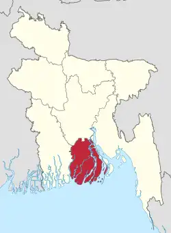
Indurkani, also known as Zianagar, is an upazila, or sub-district, of the Pirojpur District in Barisal Division, Bangladesh.[1][2]
History
On 28 July 1980, President Ziaur Rahman turned Indurkani river police station into a full police station. On 21 April 2002, Prime Minister Khaleda Zia renamed Indurkani into Zianagar Upazila. On 9 January 2017, the National Implementation Committee for Administrative Reform led by Prime Minister Sheikh Hasina renamed Zianagar Upazila back to Indurkani Upazila.[3][4]
Administration
Indurkani Upazila is divided into five union parishads: Indurkani Shadar, Chandipur, Balipara, Parerhat, and Pattashi. The union parishads are subdivided into 29 mauzas and 48 villages.[5]
Demographics
According to the 2011 Bangladesh census, Indurkani Upazila had 17,199 households and a population of 77,217. 18,847 (24.41%) were under 10 years of age. Indurkani has a literacy rate (age 7 and over) of 61.2%, compared to the national average of 51.8%, and a sex ratio of 1036 females per 1000 males. 6,069 (7.86%) lived in urban areas.[6][7]
References
- ↑ "upazila List". Bangladesh National Portal.
- ↑ "List of Upazila Nirbahi Officers". Ministry of Public Administration. Retrieved 10 January 2019.
- ↑ "Zianagar upazila becomes Indurkani again". Dhaka Tribune. 2017-02-10. Retrieved 2019-02-06.
- ↑ "Zia Nagar now Indurkani upazila again". The Independent. Dhaka. Retrieved 2019-02-06.
- ↑ "District Statistics 2011: Pirojpur" (PDF). Bangladesh Bureau of Statistics. Archived from the original (PDF) on 13 November 2014. Retrieved 14 July 2014.
- 1 2 "Community Report: Pirojpur" (PDF). Population & Housing Census 2011. Bangladesh Bureau of Statistics. Retrieved 15 August 2018.
- ↑ "Bangladesh Population & Housing Census-2011, Zila Report: Pirojpur" (PDF). Bangladesh Bureau of Statistics. p. 18.
