| Inyaptuk Golets | |
|---|---|
| Голец Иняптук | |
 Panoramic view of the mountain | |
| Highest point | |
| Elevation | 2,514 m (8,248 ft)[1] |
| Prominence | 1,286 m (4,219 ft)[1] |
| Coordinates | 56°22′38″N 110°04′25″E / 56.37722°N 110.07361°E |
| Geography | |
 Inyaptuk Golets | |
| Parent range | Synnyr, North Baikal Highlands |
| Climbing | |
| Easiest route | From Mama |
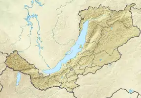
Inyaptuk Golets (Russian: Иняптук Голец) is a peak in the North Baikal Highlands. Administratively it is part of Buryatia, Russian Federation.[2]
Geography
This 1,908 m (6,260 ft) high mountain is the highest point of the North Baikal Highlands, part of the South Siberian System of ranges. It is located in the southern part of the highland area, to the north of the northern end of Lake Baikal, in Severo-Baykalsky District.[3] River Chuya has its sources in the northern slopes of the mountain.[4]
Inyaptuk is a ‘’golets’’-type of mountain with a bald peak belonging to the Synnyr Massif, one of the subranges of the North Baikal Highlands mountain system.[5]
See also
References
External links
This article is issued from Wikipedia. The text is licensed under Creative Commons - Attribution - Sharealike. Additional terms may apply for the media files.