| Jägala river Kehra jõgi, Kiigumõisa jõgi | |
|---|---|
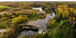 Jägala Falls (2019) | |
| Location | |
| Country | Estonia |
| County | Harju, Järva |
| Physical characteristics | |
| Source | |
| • location | Ahula |
| • coordinates | 59°06′49″N 25°44′14″E / 59.11366°N 25.73728°E |
| • elevation | 84 m (276 ft) |
| Mouth | Gulf of Finland |
• location | Jõesuu |
• coordinates | 59°28′51″N 25°08′42″E / 59.4807°N 25.1451°E |
• elevation | 0 m (0 ft) |
| Length | 98.8 km (61.4 mi) |
| Basin size | 1,481.3 km2 (571.9 sq mi) |
| Basin features | |
| Cities | Jõesuu, Jägala, Kehra, Kaunissaare |
| Tributaries | |
| • left | Sae Stream, Kiruoja, Pikva Stream, Anija Stream, Jõelähtme |
| • right | Ambla, Jänijõgi, Mustjõgi, Aavoja, Soodla |
The Jägala is a 98.8 km (61.4 mi) long river in northern Estonia that flows into the Gulf of Finland in Jõesuu, Harju county.
The river runs mostly northwest and through Järva and Harju counties. Jägala Falls, the highest waterfall in Estonia, is located on the river.
Several reservoirs are located on the river. Kehra pulp mill is located on the left bank of the river. The river is part of the Tallinn water supply system. The basin area of the river is 1,481.3 km2 (571.9 sq mi).[1]
See also
References
- ↑ "Jägala jõgi". keskkonnaportaal.ee (in Estonian). Retrieved 2021-03-06.
- ↑ "Keskkonnaregister 4.7.1.7". register.keskkonnainfo.ee (in Estonian). Retrieved 12 March 2020.
This article is issued from Wikipedia. The text is licensed under Creative Commons - Attribution - Sharealike. Additional terms may apply for the media files.