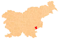
Javorovica | |
|---|---|
 Javorovica Location in Slovenia | |
| Coordinates: 45°48′22.49″N 15°21′27.58″E / 45.8062472°N 15.3576611°E | |
| Country | |
| Traditional region | Lower Carniola |
| Statistical region | Southeast Slovenia |
| Municipality | Šentjernej |
| Area | |
| • Total | 8.58 km2 (3.31 sq mi) |
| Elevation | 549.5 m (1,802.8 ft) |
| Population (2002) | |
| • Total | 38 |
| [1] | |
Javorovica (pronounced [ˈjaːʋɔɾɔʋitsa]) is a village in the Gorjanci Hills in the Municipality of Šentjernej in southeastern Slovenia. Its territory extends southwards right to the border with Croatia. The area is part of the traditional region of Lower Carniola. It is now included in the Southeast Slovenia Statistical Region.[2]
Name
Javorovica was attested in historical sources as Yauriz in 1297, Jaworwiz in 1306, Jabrowitz in 1330, and Jagrawicz in 1371, among other spellings.[3] The name is derived from the common noun javor 'maple', referring to the local vegetation.[4][5]
Cultural heritage
A former chapel dedicated to Saint Oswald has now been converted into a memorial to Partisans that died in the Gorjanci Hills during the Second World War.[6]
References
- ↑ Statistical Office of the Republic of Slovenia
- ↑ Šentjernej municipal site
- ↑ "Javorovica". Slovenska historična topografija. ZRC SAZU Zgodovinski inštitut Milka Kosa. Retrieved October 4, 2020.
- ↑ Miklosich, Franz (1874). Die slavischen Ortsnamen aus Appellativen. Vienna: Karl Gerold's Sohn. p. 36.
- ↑ Bezlaj, France (1956). Slovenska vodna imena. Ljubljana: Slovenska akademija znanosti in umetnosti. p. 236.
- ↑ Slovenian Ministry of Culture register of national heritage reference number ešd 9554
External links
This article is issued from Wikipedia. The text is licensed under Creative Commons - Attribution - Sharealike. Additional terms may apply for the media files.
