Jayawijaya Regency
Kabupaten Jayawijaya | |
|---|---|
 Seal | |
| Motto(s): Yogotak Hubuluk Mutuk Hanorogo (Tomorrow Must Be Better Than Today) | |
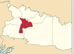 Location in Highland Papua | |
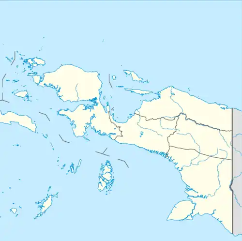 Jayawijaya Regency Location in Indonesian Papua 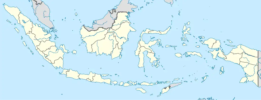 Jayawijaya Regency Location in Indonesia | |
| Coordinates: 4°05′00″S 139°05′00″E / 4.0833°S 139.0833°E | |
| Country | |
| Region | Papua |
| Province | Highland Papua |
| Capital | Wamena |
| Government | |
| • Regent | Wempi Wetipo |
| • Vice Regent | Jhon R. Banua |
| Area | |
| • Total | 13,925.31 km2 (5,376.59 sq mi) |
| Population (mid 2022 estimate)[1] | |
| • Total | 277,923 |
| • Density | 20/km2 (52/sq mi) |
| Time zone | UTC+9 (Indonesia Eastern Time) |
| Area code | (+62) 969 |
| Website | jayawijayakab.go.id |
Jayawijaya Regency is one of the regencies (kabupaten) in the Indonesian province of Highland Papua. It occupies an area of 13,925.31 km2 in the Baliem Valley, situated in the central highlands of the province. It had a population of 196,085 at the 2010 Census,[2] and 269,553 at the 2020 Census;[3] the official estimate as at mid 2022 was 277,923 - comprising 144,500 males and 133,423 females.[1] Its capital is the town of Wamena.
History
As originally created, Jayawijaya Regency covered an area coincident with the whole of what in 2022 became Highland Papua Province. However on 11 December 2002 three new Regencies - Bintang Mountains Regency (Kabupaten Pegunungan Bintang), Tolikara Regency and Yahukimo Regency - were created from parts of Jayawijaya Regency. Subsequently on 4 January 2008 another four new Regencies - Lanny Jaya Regency, Central Mamberamo Regency (Kabupaten Mamberamo Tengah), Nduga Regency and Yalimo Regency - were created from further parts of Jayawijaya Regency. All eight regencies were brought together again in 2022 in the new province of Highland Papua.
Administrative districts

At the time of the 2010 Census, the Jayawijaya Regency comprised eleven districts (distrik), listed below with their populations at the 2010 Census. During the following ten years, the number of districts was raised to forty by the splitting of existing districts, and these are all shown below with their current areas and their populations at the 2010 Census[2] and the 2020 Census,[3] together with the official estimates as at mid 2022.[1] The table also includes the locations of the district administrative centres, the number of administrative villages in each district (totaling 328 rural kampung and 4 urban kelurahan), and its post code.
| Kode Wilayah | Name of District (distrik) | Area in km2 | Pop'n 2010 Census | Pop'n 2020 Census | Pop'n mid 2022 Estimate | Admin centre | No. of villages | Post code |
|---|---|---|---|---|---|---|---|---|
| 95.01.01 | Wamena | 249.31 | 62,552 | 64,967 | 65,766 | Wamena Kota | 11 (a) | 99511 |
| 95.01.09 | Asolokobal | 375.51 | 15,349 | 4,985 | 5,337 | Asolokobal | 9 | 99501 |
| 95.01.06 | Walelagama | 412.33 | 11,181 | 2,871 | 2,672 | Walelagama | 6 | 99510 |
| 95.01.12 | Trikora | 190.07 | 1,472 | 1,490 | Trikora | 6 | 99508 | |
| 95.01.13 | Napua | 246.64 | 5,425 | 5,491 | Napua | 9 | 99505 | |
| 95.01.14 | Walaik | 176.33 | 3,287 | 3,327 | Walaik | 5 | 99509 | |
| 95.01.15 | Wouma | 243.09 | 6,760 | 6,843 | Wouma | 7 | 99514 | |
| 95.01.35 | Welesi | 250.21 | 3,045 | 3,261 | Welesi | 7 | 99512 | |
| 95.01.36 | Asotipo | 319.57 | 9,913 | 10,614 | Asotipo | 10 | 99502 | |
| 95.01.37 | Maima | 188.61 | 7,083 | 7,584 | Maima | 7 | 99504 | |
| 95.01.04 | Hubikosi | 547.90 | 17,495 | 8,218 | 8,017 | Hubikosi | 11 | 99552 |
| 95.01.10 | Pelebaga | 514.18 | 10,220 | 14,197 | 15,960 | Wililimo | 13 | 99554 |
| 95.01.17 | Ibele | 333.13 | 9,089 | 10,218 | Ibele | 10 | 99553 | |
| 95.01.18 | Tailarek | 320.79 | 3,809 | 4,282 | Taelarek | 8 | 99555 | |
| 95.01.16 | Hubikiak | 541.70 | 14,056 | 13,712 | Hubikiak | 8 | 99551 | |
| 95.01.03 | Asologaima | 182.37 | 37,535 | 5,073 | 4,722 | Kimbim | 10 | 99531 |
| 95.01.07 | Musatfak | 994.85 | 7,209 | 4,203 | 3,912 | Temia | 10 | 99533 |
| 95.01.30 | Silo Karno Doga | 309.75 | 5,065 | 4,715 | Wonenggulik | 8 | 99535 | |
| 95.01.31 | Piramid | 297.18 | 5,122 | 4,768 | Piramid | 10 | 99534 | |
| 95.01.32 | Muliama | 337.83 | 5,780 | 5,380 | Muliama | 12 | 99532 | |
| 95.01.39 | Warne | 168.16 | 1,927 | 1,794 | Warne | 4 | 99536 | |
| 95.01.02 | Kurulu | 492.33 | 24,732 | 7,039 | 6,552 | Jiwika | 12 | 99521 |
| 95.01.21 | Usilimo | 321.58 | 3,567 | 3,320 | Usilimo | 10 | 99524 | |
| 95.01.22 | Wita Waya | 217.24 | 2,058 | 1,916 | Tulem | 5 | 99526 | |
| 95.01.23 | Libarek | 213.23 | 2,287 | 2,129 | Muliama | 5 | 99522 | |
| 95.01.24 | Wadangku | 219.90 | 2,471 | 2,300 | Wadangku | 5 | 99525 | |
| 95.01.25 | Pisugi | 336.03 | 3,253 | 3,028 | Pisugi | 7 | 99523 | |
| 95.01.05 | Bolakme | 429.07 | 7,175 | 5,117 | 5,632 | Bolakme | 12 | 99541 |
| 95.01.08 | Wolo | 339.67 | 3,068 | 8,912 | 11,159 | Wolo | 8 | 99548 |
| 95.01.11 | Yalengga | 689.06 | 2,244 | 3,051 | 3,487 | Yalengga | 11 | 99549 |
| 95.01.27 | Tagime | 406.26 | 5,795 | 6,378 | Tagime | 11 | 99546 | |
| 95.01.28 | Molagalome | 228.67 | 2,644 | 2,910 | Molagalome | 6 | 99545 | |
| 95.01.29 | Tagineri | 291.59 | 3,495 | 3,847 | Tagineri | 9 | 99547 | |
| 95.01.33 | Bugi | 463.83 | 3,655 | 4,576 | Bugi | 8 | 99543 | |
| 95.01.34 | Bpiri | 348.12 | 1,629 | 2,040 | Dlonggoki | 7 | 99542 | |
| 95.01.26 | Koragi | 465.94 | 3,428 | 3,918 | Koragi | 5 | 99544 | |
| 95.01.40 | Wesaput | 249.31 | 10,448 | 10,576 | Ilokama | 8 (b) | 99513 | |
| 95.01.20 | Siepkosi | 354.72 | 3,376 | 3,143 | Siepkosi | 9 | 99507 | |
| 95.01.19 | Itlay Hisage | 498.95 | 4,370 | 4,068 | Lukaken | 9 | 99503 | |
| 95.01.38 | Popugoba | 160.30 | 6,611 | 7,079 | Popugoba | 4 | 99506 | |
| Totals | 13,925.31 | 196,085 | 269,553 | 277,923 | Wamena | 332 |
Notes: (a) including the three kelurahan of Wamena Kota (Wamena town), Sinakma and Sinapuk. (b) including the kelurahan of Ilokama.
Note that those districts with 2010 populations given in the 2010 Population column (and numbered from 95.01.01 to 95.01.11) were the eleven districts extent in 2010; the remaining twenty-nine districts with no figure given in the 2010 Population column (and numbered from 95.01.12 to 95.01.40) were those created from the original eleven districts subsequent to 2010.
References
External links
Regencies and cities of Highland Papua | ||
|---|---|---|
Capital: Wamena | ||
| Regencies |  | |