Jianghan
江汉区 | ||||||||||||||||||||||||||||||||||||
|---|---|---|---|---|---|---|---|---|---|---|---|---|---|---|---|---|---|---|---|---|---|---|---|---|---|---|---|---|---|---|---|---|---|---|---|---|
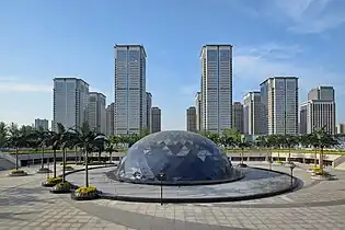
 Wangjiadun CBD | ||||||||||||||||||||||||||||||||||||
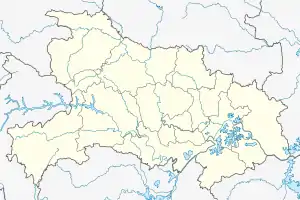
 Jianghan Location in Hubei | ||||||||||||||||||||||||||||||||||||
| Coordinates: 30°36′10″N 114°15′51″E / 30.6029°N 114.2642°E[1] | ||||||||||||||||||||||||||||||||||||
| Country | People's Republic of China | |||||||||||||||||||||||||||||||||||
| Province | Hubei | |||||||||||||||||||||||||||||||||||
| Sub-provincial city | Wuhan | |||||||||||||||||||||||||||||||||||
| Area | ||||||||||||||||||||||||||||||||||||
| • Total | 33.43 km2 (12.91 sq mi) | |||||||||||||||||||||||||||||||||||
| Population (2010)[3] | ||||||||||||||||||||||||||||||||||||
| • Total | 683,492 | |||||||||||||||||||||||||||||||||||
| • Density | 20,445/km2 (52,950/sq mi) | |||||||||||||||||||||||||||||||||||
| Time zone | UTC+8 (China Standard) | |||||||||||||||||||||||||||||||||||
| Wuhan district map |
| |||||||||||||||||||||||||||||||||||
| Website | 武汉市江汉区人民政府 (translation: Wuhan City Jianghan District People's Government) (in Simplified Chinese) | |||||||||||||||||||||||||||||||||||
Jianghan District (simplified Chinese: 江汉区; traditional Chinese: 江漢區; pinyin: Jiānghàn Qū, lit. Yangtze and Han River) forms part of the urban core of and is one of 13 urban districts of the prefecture-level city of Wuhan, the capital of Hubei Province, China. The district is part of the historical Hankou.
Geography

Jianghan District is situated on the northwest (left) bank of the Yangtze River. It is both the least spacious and most densely populated of the districts of Wuhan.[2][3] It borders Dongxihu to the north, Jiang'an to the northeast, Hanyang to the south, and Qiaokou to the west; on the opposite bank it borders Wuchang.
Wuhan Center and the Wuhan New International Trade Tower is located in Jianghan District, the latter of which houses the Consulate General of the United States and France in Wuhan, Hong Kong Economic and Trade Office in Wuhan, and offices of various international corporations.
Administrative divisions
Jianghan District administers:[4][5][6]
| # | Name | Chinese (S) | ||||
|---|---|---|---|---|---|---|
| Subdistricts | ||||||
| 1 | Minzu Subdistrict Nationalism | 民族街道 | ||||
| 2 | Minquan Subdistrict Democracy | 民权街道 | ||||
| 3 | Hualou Subdistrict Flower Tower | 花楼街道 | ||||
| 4 | Shuita Subdistrict Water Pagoda | 水塔街道 | ||||
| 5 | Manchun Subdistrict | 满春街道 | ||||
| 6 | Qianjin Subdistrict Progress | 前进街道 | ||||
| 7 | Minyi Subdistrict | 民意街道 | ||||
| 8 | Xinhua Subdistrict New China | 新华街道 | ||||
| 9 | Wansong Subdistrict Myriad Pines | 万松街道 | ||||
| 10 | Beihu Subdistrict North Lake | 北湖街道 | ||||
| 11 | Tangjiadun Subdistrict Tang Family Dun | 唐家墩街道 | ||||
| 12 | Changqing Subdistrict | 常青街道 | ||||
| 13 | Hanxing Subdistrict | 汉兴街道 | ||||
References
- ↑ Google (2 July 2014). "Jianghan" (Map). Google Maps. Google. Retrieved 2 July 2014.
- 1 2 "Wuhan Statistical Yearbook 2010" (PDF). Wuhan Statistics Bureau. p. 15. Archived from the original (PDF) on 5 November 2011. Retrieved 31 July 2011.
- 1 2 "武汉市2010年第六次全国人口普查主要数据公报" (in Chinese). Wuhan Statistics Bureau. 11 May 2011. Archived from the original on 25 October 2011. Retrieved 11 June 2011.
- ↑ "江汉概况" (in Chinese). 区委宣传部、区政府办公室. 11 January 2016. Archived from the original on 26 December 2017. Retrieved 26 December 2017.
- ↑ "江汉区历史沿革 (translation: The Historical Development of Jianghan District)" (in Chinese). 行政区划网站 (translation: Administrative Divisions Website). 8 July 2014. Retrieved 26 December 2017.
- ↑ 2018年统计用区划代码和城乡划分代码:木鱼镇 [2018 Statistical Area Numbers and Rural-Urban Area Numbers: Jianghan District] (in Simplified Chinese). National Bureau of Statistics of the People's Republic of China. 2018. Retrieved 31 January 2019.
