| Kalaallit Nunaat high arctic tundra | |
|---|---|
 | |
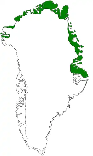
 Ecoregion territory (in green) | |
| Ecology | |
| Realm | Nearctic |
| Biome | Tundra |
| Borders | |
| Geography | |
| Area | 304,321 km2 (117,499 sq mi) |
| Country | Denmark |
| State | Greenland |
| Coordinates | 70°15′N 70°45′W / 70.25°N 70.75°W |
The Kalaallit Nunaat high arctic tundra ecoregion covers the coastal areas of northern including the upper half of the west coast and the upper one-third of the east coast.[1] Greenland (called Kalaallit Nunaat in the Greenlandic language). Areas inland of this strip of land are either covered in ice or bare rock. About one-third of the region is covered by mosses and lichens, and another 3% by herbaceous vegetation and shrubs. The largest national park in the world, Northeast Greenland National Park, protects a majority of the land within the ecoregion.[2][3][4][5] The Pituffik Space Base is also located in this ecoregion.[6]
Location and description
The ecoregion covers the coastal fringe of Greenland, from 75° N latitude at Melville Bay, around the northern coast to 70° N at Scoresby Bay on the east coast. The coastal bands south of this are in the Kalaallit Nunaat low arctic tundra ecoregion. The coast is rugged, although less so than the south, with deep inlets from the sea. The most ice-free of this coastal band is on the northeast, in the region of Peary Land. The lower soil is permafrost.[5]
Climate
The climate of the ecoregion is Tundra climate (Köppen climate classification ET), a local climate in which at least one month has an average temperature high enough to melt snow (0 °C (32 °F)), but no month with an average temperature in excess of 10 °C (50 °F).[7][8] There is less precipitation than in the south.
Flora and fauna
Plant life is sparse, with scattered fields of heath and fellfields of low herbaceous cushion plants. There are no trees. Vegetation is strongest on the east coast, with the greatest extents towards the south. Plant adaptations required to live in this harsh environment include tolerating cold, long periods of darkness, and precipitation that mostly falls as snow.[5] 50% of the territory is bare rock and ice, or very sparse vegetation. 30% of the ecoregion has a cover of moss and lichen, and another 3% of herbaceous cover and shrubs. Some small areas on the east coast have greater plant life around hot springs, particularly marsh willowherb (Epilobium palustre)) and the northern green orchid (Platanthera hyperborea).[4]
Studies have identified eight types of vegetation on the east coast from 72 to 79° N:
- Dwarf shrub heaths (Cassiope tetragona, Salix arctica, Vaccinium uliginosum or Betula nana,
- Grasslands (dry in summer: Arctagrostis latifolia, Carex bigelowii, sooty sedge (Carex misandra), and Eriophorum triste)
- Permanently wet fens (Carex stans, Eriophorum scheuchzeri, and Arctagrostis latifolia)
- Snowbeds (Phippsia algida, Salix herbacea, Trisetum spicatum and Erigeron humilis);
- Open, graminoid Dryas-heaths and fellfields on dry soil (Carex nardina, Carex rupestris, and Kobresia myosuroides);
- Fellfields (Calamagrostis purpurascens and Carex supina)
- Communities on wet ground that is covered by an organic crust (Koenigia islandica and Festuca hyperborea);
- Halophytic vegetation (Puccinellia phryganodes and Carex subspathacea).
.jpg.webp)
Protected areas
Over 71% of the ecoregion is officially protected.[4] Portions of the ecoregion lie in:
- Northeast Greenland National Park. The largest national park in the world.
- Kilen Ramsar site. The northernmost Ramsar wetland in the world.[9]
References
- ↑ https://www.oneearth.org/ecoregions/kalaallit-nunaat-high-arctic-tundra/
- ↑ "Kalaallit Nunaat high arctic tundra". World Wildlife Federation. Retrieved March 21, 2020.
- ↑ "Map of Ecoregions 2017". Resolve, using WWF data. Retrieved September 14, 2019.
- 1 2 3 "Kalaallit Nunaat high arctic tundra". Digital Observatory for Protected Areas. Retrieved August 1, 2020.
- 1 2 3 "Kalaallit Nunaat high arctic tundra". The Encyclopedia of Earth. Retrieved August 28, 2020.
- ↑ https://www.petersonschriever.spaceforce.mil/Pituffik-SB-Greenland/
- ↑ Kottek, M., J. Grieser, C. Beck, B. Rudolf, and F. Rubel, 2006. "World Map of Koppen-Geiger Climate Classification Updated" (PDF). Gebrüder Borntraeger 2006. Retrieved September 14, 2019.
{{cite web}}: CS1 maint: multiple names: authors list (link) CS1 maint: numeric names: authors list (link) - ↑ "Dataset - Koppen climate classifications". World Bank. Retrieved September 14, 2019.
- ↑ "Kilen RAMSAR site". RAMSAR Sites Information Service. Retrieved November 4, 2020.
External links
 Media related to Kalaallit Nunaat high arctic tundra (WWF) at Wikimedia Commons