Kampochora
Καμπόχωρα | |
|---|---|
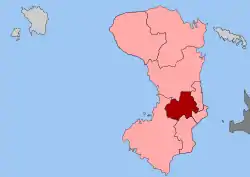
 Kampochora Location within the regional unit  | |
| Coordinates: 38°20′N 26°06′E / 38.333°N 26.100°E | |
| Country | Greece |
| Administrative region | North Aegean |
| Regional unit | Chios |
| Municipality | Chios |
| • Municipal unit | 50.6 km2 (19.5 sq mi) |
| Population (2011)[1] | |
| • Municipal unit | 2,897 |
| • Municipal unit density | 57/km2 (150/sq mi) |
| Time zone | UTC+2 (EET) |
| • Summer (DST) | UTC+3 (EEST) |
| Vehicle registration | ΧΙ |
Kampochora or Kampos (Greek: Καμπόχωρα, Κάμπος), literally plain, is a former municipality on the island of Chios, North Aegean, Greece. Since the 2011 local government reform it is part of the municipality Chios, of which it is a municipal unit.[2] It is located in the south-central part of the island. It has a land area of 50.571 km².[3] Its population was 2,897 at the 2011 census. The seat of the municipality was in Chalkeio (pop. 950). Other large towns include Ágios Geórgios Sykoúsis (579), Dafnón (385), and Vasileónoikon (377).
The area started to develop since the Genoese rule of the island in 13th century, when the most wealthy Chiot Greek and Genoese families started to building their houses.
Gallery
 Byzantine church Panagia Kokorovilia
 Panagia Krina in Vavili village
 Panagia Sikelia
 Panagia Agiodektini
 Old house
 Topaka farm
 Argenti farm
 Patrinos farm
 Old building
References
- ↑ "Απογραφή Πληθυσμού - Κατοικιών 2011. ΜΟΝΙΜΟΣ Πληθυσμός" (in Greek). Hellenic Statistical Authority.
- ↑ "ΦΕΚ B 1292/2010, Kallikratis reform municipalities" (in Greek). Government Gazette.
- ↑ "Population & housing census 2001 (incl. area and average elevation)" (PDF) (in Greek). National Statistical Service of Greece. Archived from the original (PDF) on 2015-09-21.
This article is issued from Wikipedia. The text is licensed under Creative Commons - Attribution - Sharealike. Additional terms may apply for the media files.