Kandal
កណ្ដាល | |
|---|---|
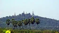
 Oudong, the 17th century capital of Cambodia, is located in Kandal province | |
 Seal | |
 Map of Cambodia highlighting Kandal province | |
| Country | |
| Provincial status | 1907 |
| Capital | Ta Khmau |
| Subdivisions | 10 districts; 1 municipality |
| Government | |
| • Governor | Kong Sophorn (CPP) |
| • National Assembly | 11 / 125
|
| Area | |
| • Total | 3,179 km2 (1,227 sq mi) |
| • Rank | 19th |
| Elevation | 10 m (30 ft) |
| Population (2019)[1] | |
| • Total | |
| • Rank | 2nd |
| • Density | 378/km2 (980/sq mi) |
| • Rank | 2nd |
| Time zone | UTC+07:00 (ICT) |
| ISO 3166 code | KH-8 |
| HDI (2017) | 0.591[2] medium |
Kandal (Khmer: កណ្ដាល, Kândal [kɑnˈɗaːl]; lit. 'Middle') is a province of Cambodia located in the southeast portion of the country. It completely surrounds the Cambodian capital of Phnom Penh and borders the provinces of Kampong Speu and Takéo to the west, Kampong Chhnang and Kampong Cham to the north, Prey Veng to the east, and shares an international border with Vietnam (An Giang and Đồng Tháp) to the south. It is the second most populous province in Cambodia after the capital Phnom Penh.[3] Its capital and largest city is Ta Khmau, which is approximately eight kilometres (5.0 mi) south of central Phnom Penh. Kandal is one of the wealthier provinces in the country.
Geography
Physical
Kandal province completely surrounds the capital Phnom Penh. The province is also a part of the greater Phnom Penh Metropolitan Area with more than a million people living in and around the province. While traveling out of Phnom Penh, the boundary between the two provinces is nearly unrecognizable.
The province consists of the typical plain wet area, covering rice fields and other agricultural plantations. The average altitude of the province is no more than 10 meters above sea level. The province also features two of the biggest rivers in the country, the Bassac and Mekong Rivers.[4]
Climate
The province has a warm and humid tropical climate. The monsoon season normally begins in May and runs through October, while the rest of the year is the dry season. The warmest period of the year occurs between March and May, while the coolest period is from November through March.[5]
Economy
Kandal province serves as an economic belt of the capital Phnom Penh. Farming and fishing are the two main industries of the province. Major products include palm oil, peanuts, rice, and pepper. In addition to farming and fishing, the province also supports thriving cottage industries that specialize in wood carving, silk, and handicrafts.
Many garment factories are located in Kandal province, which hires more than 500,000 workers.
Administrative divisions

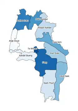
The province is subdivided into 10 districts and 2 municipality. The districts are further subdivided into 146 communes (khum) and 1087 villages.
| ISO code | Name | Khmer |
|---|---|---|
| 08-01 | Kandal Stueng | កណ្ដាលស្ទឹង |
| 08-02 | Kien Svay | កៀនស្វាយ |
| 08-03 | Khsach Kandal | ខ្សាច់កណ្ដាល |
| 08-04 | Kaoh Thum | កោះធំ |
| 08-05 | Leuk Daek | លើកដែក |
| 08-06 | Lvea Aem | ល្វាឯម |
| 08-07 | Mukh Kampul | មុខកំពូល |
| 08-08 | Angk Snuol | អង្គស្នួល |
| 08-09 | Ponhea Lueu | ពញាឮ |
| 08-10 | S'ang | ស្អាង |
| 08-11 | Ta Khmau | តាខ្មៅ |
| 08-12 | Arey Ksat | អរិយក្សត្រ |
2 districts Khsach Kandal and Lvea Aem in east Mekong river
Parliament
Religion
Religion in Kandal (2019 census)[6]
The state religion is Theravada Buddhism. More than 98.3% of the people in Kandal are Buddhists. Chams have been practicing Islam for hundreds of years. A small percentage follow Christianity.
References
- ↑ "General Population Census of the Kingdom of Cambodia 2019 – Final Results" (PDF). National Institute of Statistics. Ministry of Planning. 26 January 2021. Retrieved 3 February 2021.
- ↑ "Sub-national HDI - Area Database - Global Data Lab". hdi.globaldatalab.org. Retrieved 2018-09-13.
- ↑ Mom, Kunthear (7 August 2019). "Cambodia's population reaches 15.2 million". Khmer Times. Retrieved 8 August 2019.
- ↑ TC-Kandal Geography
- ↑ TC-Kandal
- ↑ "Final General Population Census 2019-English.pdf" (PDF). National Institute of Statistics Ministry of planning. October 2020.