Kent, Kansas | |
|---|---|
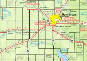 KDOT map of Reno County (legend) | |
 Kent  Kent | |
| Coordinates: 38°02′25″N 97°48′41″W / 38.04028°N 97.81139°W | |
| Country | United States |
| State | Kansas |
| County | Reno |
| Elevation | 1,499 ft (457 m) |
| Population | |
| • Total | 0 |
| Time zone | UTC-6 (CST) |
| • Summer (DST) | UTC-5 (CDT) |
| Area code | 620 |
| GNIS ID | 481917 [1] |
Kent is a ghost town in Reno County, Kansas, United States.[1] It was located 7 miles southeast of Hutchinson at the intersection of Kent Road and the Atchison, Topeka and Santa Fe Railway. It is the site of a former post office; and a former station on the ATSF Railway (the station was the site of a locomotive change on the Scott Special).
References
Further reading
External links
Municipalities and communities of Reno County, Kansas, United States | ||
|---|---|---|
| Cities | 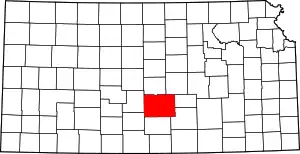 Map of Kansas highlighting Reno County | |
| Unincorporated communities | ||
| Ghost towns | ||
| Townships | ||
| Footnotes | †This community is designated a Census-Designated Place (CDP) by the United States Census Bureau. | |
This article is issued from Wikipedia. The text is licensed under Creative Commons - Attribution - Sharealike. Additional terms may apply for the media files.