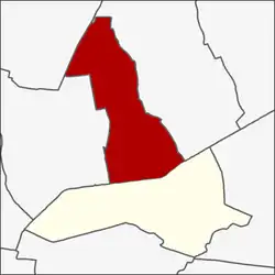
Khlong Chan
คลองจั่น | |
|---|---|
 Location in Bang Kapi District | |
| Country | |
| Province | Bangkok |
| Khet | Bang Kapi |
| Area | |
| • Total | 12.062 km2 (4.657 sq mi) |
| Population (2020) | |
| • Total | 76,934 |
| Time zone | UTC+7 (ICT) |
| Postal code | 10240 |
| TIS 1099 | 100601 |

Khlong Chan (Thai: คลองจั่น, pronounced [kʰlɔ̄ːŋ t͡ɕàn]) is a neighbourhood in Bangkok, also a khwaeng (sub-district) of Bang Kapi District, Bangkok.
Toponymy
Khlong Chan is the name of a tributary of Khlong Saen Saep canal. The longest khlong (canal) in Thailand that flows from the downtown Bangkok to the eastern part at province of Chachoengsao which flows through the area of Bang Kapi.
The name Khlong Chan means a canal filled with chan (Millettia brandisiana) trees. Because this area in the past there were chan plants lined on both sides of the canal.
Geography
Khlong Chan is an area in the southeast of Bangkok and is the northern part of Bang Kapi District.
The area bounded by other areas (from the north clockwise): Nawamin in Bueng Kum District, Khlong Kum in Bueng Kum District, Hua Mak in its district, Phlabphla in Wang Thonglang District, and Wang Thonglang in Wang Thonglang District, with Lat Phrao in Lat Phrao District.[2] [3]
Places
- Bang Kapi District Office
- Happy Land
- The Mall Bangkapi
- Makro Lat Phrao
- Tawanna Market
- Vejthani Hospital
- National Housing Authority
References
- ↑ Administrative Strategy Division, Strategy and Evaluation Department, Bangkok Metropolitan Administration (2021). สถิติกรุงเทพมหานครประจำปี 2563 [Bangkok Statistics 2020] (PDF) (in Thai). Retrieved 27 November 2021.
{{cite web}}: CS1 maint: multiple names: authors list (link) - ↑ "ประกาศกรุงเทพมหานคร เรื่อง พื้นที่แขวงหัวหมาก และเปลี่ยนแปลงพื้นที่แขวงคลองจั่น เขตบางกะปิ" (PHP). Dl.parliament.go.th (in Thai). 1997-12-24. Retrieved 2021-09-15.
- ↑ "Khlong Chan". Google Map (in Thai).