Kiedrzyn | |
|---|---|
 Church of St. Brother Albert in Kiedrzyn | |
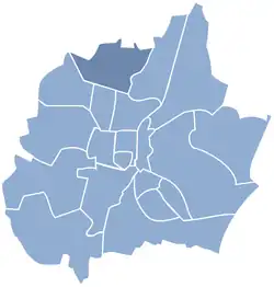
 Location of Kiedrzyn within Częstochowa | |
| Coordinates: 50°50′49″N 19°06′25″E / 50.847°N 19.107°E | |
| Country | |
| Voivodeship | Silesian |
| County/City | Częstochowa |
| Government | |
| • District Chairman | Mariusz Musiał |
| Area | |
| • Total | 7.77 km2 (3.00 sq mi) |
| Population (2014) | |
| • Total | 2,940 |
| • Density | 380/km2 (980/sq mi) |
| Time zone | UTC+1 (CET) |
| • Summer (DST) | UTC+2 (CEST) |
| Area code | (+48) 34 |
Kiedrzyn is a dzielnica (district) of Częstochowa, Silesian Voivodeship, southern Poland. It is located in the north-west part of the city, between roads to Łask and Działoszyn. Kiedrzyn has an area of 7.77 km2 and on April 30, 2014 had 2,940 inhabitants.[1]
Kiedrzyn is called "the district of florists" - majority of the houses have their own greenhouses.[2]
In district is located local sport club Orzeł Kiedrzyn and since 1922 Volunteer Fire Brigade. In Kiedrzyn are 2 churches: Church of St. Brother Albert Chmielowski and Church of St. Andrew Bobola.[3]
Kiedrzyn is connected to the city by public transport. The bus line number 13 runs through the district.[4]
References
- ↑ "Algorytm podziału środków | Konsultacje Społeczne Częstochowa" (in Polish). Retrieved 2018-12-28.
- ↑ "Spacerem wzdłuż Warty - relacja, zdjęcia, mapa wycieczki Polskie Szlaki". www.polskieszlaki.pl. Retrieved 2018-12-28.
- ↑ "Urząd Miasta Częstochowy - Kiedrzyn -". www.czestochowa.pl. Retrieved 2018-12-28.
- ↑ "Częstochowa, rozkład jazdy linia 13". www.m2.rozkladzik.pl. Retrieved 2018-12-28.
This article is issued from Wikipedia. The text is licensed under Creative Commons - Attribution - Sharealike. Additional terms may apply for the media files.