Kiiminki | |
|---|---|
Former municipality | |
| Kiimingin kunta Kiminge kommun | |
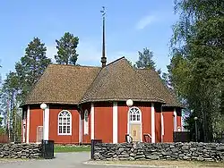 Kiiminki Church, built in 1760 | |
 Coat of arms | |
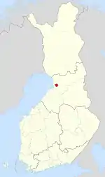 Location of Kiiminki in Finland | |
| Coordinates: 65°08′N 025°46.5′E / 65.133°N 25.7750°E | |
| Country | Finland |
| Region | Northern Ostrobothnia |
| Sub-region | Oulu sub-region |
| Charter | 1867 |
| Government | |
| • Municipal manager | Jukka Weisell |
| Area | |
| • Total | 339.00 km2 (130.89 sq mi) |
| • Land | 12.18 km2 (4.70 sq mi) |
| • Water | 326.82 km2 (126.19 sq mi) |
| Population (31 December 2012)[2] | |
| • Total | 13,320 |
| • Density | 39/km2 (100/sq mi) |
| Time zone | UTC+2 (EET) |
| • Summer (DST) | UTC+3 (EEST) |
| Website | www.kiiminki.fi |
Kiiminki (Swedish: Kiminge) was a municipality of Finland. Along with Haukipudas, Oulunsalo and Yli-Ii municipalities it was merged with the city of Oulu on 1 January 2013. Kiiminki municipality was part of the Oulu province in the Northern Ostrobothnia region. The municipality had a population of 13,320 (31 December 2012)[2] and covered an area of 339.00 square kilometres (130.89 sq mi) of which 326.82 km2 (126.19 sq mi) is water.[1] The population density is 1,093.6/km2 (2,832.4/sq mi).
Buildings and structures
There is a 326-metre tall guyed mast for FM- and TV broadcasting.
References
- 1 2 "Area by municipality as of 1 January 2011" (PDF) (in Finnish and Swedish). Land Survey of Finland. Retrieved 9 March 2011.
- 1 2 "VÄESTÖTIETOJÄRJESTELMÄ REKISTERITILANNE 31.1.2012" (in Finnish and Swedish). Population Register Center of Finland. Archived from the original on 3 October 2013. Retrieved 11 February 2014.
- ↑ "Population according to language and the number of foreigners and land area km2 by area as of 31 December 2008". Statistics Finland's PX-Web databases. Statistics Finland. Retrieved 29 March 2009.
External links
 Media related to Kiiminki at Wikimedia Commons
- Municipality of Kiiminki – Official website
| Municipalities |  | |
|---|---|---|
| Former | ||
This article is issued from Wikipedia. The text is licensed under Creative Commons - Attribution - Sharealike. Additional terms may apply for the media files.