Kořenov | |
|---|---|
 Tesařov chapel | |
 Flag  Coat of arms | |
 Kořenov Location in the Czech Republic | |
| Coordinates: 50°45′34″N 15°21′56″E / 50.75944°N 15.36556°E | |
| Country | |
| Region | Liberec |
| District | Jablonec nad Nisou |
| First mentioned | 1539 |
| Area | |
| • Total | 55.83 km2 (21.56 sq mi) |
| Elevation | 725 m (2,379 ft) |
| Population (2023-01-01)[1] | |
| • Total | 987 |
| • Density | 18/km2 (46/sq mi) |
| Time zone | UTC+1 (CET) |
| • Summer (DST) | UTC+2 (CEST) |
| Postal codes | 468 48, 468 49, 468 50 |
| Website | www |
Kořenov (German: Bad Wurzelsdorf) is a municipality and village in Jablonec nad Nisou District in the Liberec Region of the Czech Republic. It has about 1,000 inhabitants. It lies in the Jizera Mountains.
Administrative parts
The villages of Jizerka, Polubný, Příchovice and Rejdice are administrative parts of Kořenov.
Geography
Kořenov is located about 13 km (8 mi) east of Jablonec nad Nisou, on the border with Poland. It lies in the Jizera Mountains and in the eponymous protected landscape area. The highest point is the mountain Černý vrch at 1,025 m (3,363 ft) above sea level. The Jizera River forms here the entire Czech-Polish border and then shortly crosses the territory of Kořenov.
History
The first settlers came to the remote forested area in northern Bohemia in 1577 when Paul Schürer von Walthaimb established one of the oldest glassworks in the region at Rejdice. The glassworks operated until 1720.[2] After the 1620 Battle of White Mountain, the lands were seized by Albrecht von Wallenstein, who sold them to the comital Desfours dynasty. In the 18th century, German colonists came to this region. The estates were acquired by the noble House of Rohan in 1824.[3]
In 1902, the Tanvald–Kořenov cog railway connecting to the electrified Izera railway line running to Silesian Hirschberg (present-day Jelenia Góra) was put into operation. Until 1918, Bohemian Unter Wurzelsdorf belonged to the Cisleithanian part of Austria-Hungary, in the Bezirk (district) of Gablonz (now Jablonec nad Nisou), one of 94 Bohemian Bezirkshauptmannschaften.[4]
The German-speaking population was expelled after 1945.
The municipality was established in 1960 by the merger of the former market towns of Polubný and Příchovice with Rejdice and Jizerka. Kořenov was only an administrative part of Polubný, however the new municipality adopted its name.[5]
Part of Kořenov, the former hamlet of Údolí Naděje (Hoffnungstal, Polish: Zieleniec), belonged to Poland between 1945 and 1958. As part of the interstate agreement on territorial exchange, the territory then fell to Czechoslovakia.[6]
Demographics
|
|
| ||||||||||||||||||||||||||||||||||||||||||||||||||||||
| Source: Censuses[7][8] | ||||||||||||||||||||||||||||||||||||||||||||||||||||||||
Transport
Kořenov lies on the railway line from Liberec to Szklarska Poręba.
Sights

Štěpánka is the oldest observation tower in the Jizera Mountains. It was built on Hvězda mountain (959 m (3,146 ft)) in 1847. The tower is 24 m (79 ft) high and belongs to the most popular tourist destinations in the mountain range.[9]
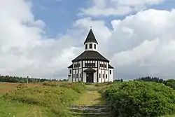
Tesařov chapel is a protestant chapel, built according to plans of Otto Bartning in 1909. Today si is used by the Moravian Church.[10]
The Church of Saint John in Polubný was built in 1789–1793. It is a Neoclassical building with Neoromanesque interiors.[11]
The Tanvald–Harrachov cog railway passes through Kořenov. It was built in 1899–1902. It is known for the steepest gradient of a railway in the country (up to 58 ‰) and for the Polubenský Tunnel, which belongs to the longest in the country with a length of 940 m (3,080 ft).[12]
Notable people
- Berthold Bartosch (1893–1968), film director
- Rudolf Burkert (1904–1985), skier
- Claus Josef Riedel (1925–2004), glassmaker
- Ladislav Rygl Sr. (born 1947), skier
References
- ↑ "Population of Municipalities – 1 January 2023". Czech Statistical Office. 2023-05-23.
- ↑ "Rejdice". Czech Glass Competence. Muzeum skla a bižuterie v Jablonci nad Nisou. Retrieved 2023-03-28.
- ↑ "Kořenov". zubacka.cz. Retrieved 2023-03-28.
- ↑ Die postalischen Abstempelungen auf den österreichischen Postwertzeichen-Ausgaben 1867, 1883 und 1890, Wilhelm Klein, 1967
- ↑ "Obec Kořenov => Historie => Historie obce". Obec Kořenov. Retrieved 2021-02-10.
- ↑ "Stezkou zaniklých sklářských hutí". Liberec Region. Retrieved 2023-03-28.
- ↑ "Historický lexikon obcí České republiky 1869–2011 – Okres Jablonec nad Nisou" (in Czech). Czech Statistical Office. 2015-12-21. pp. 3–4.
- ↑ "Population Census 2021: Population by sex". Public Database. Czech Statistical Office. 2021-03-27.
- ↑ "Rozhledna Štěpánka – nejstarší rozhledna Jizerských hor" (in Czech). CzechTourism. Retrieved 2022-11-07.
- ↑ "Tesařovská kaple Kořenov" (in Czech). CzechTourism. Retrieved 2022-11-07.
- ↑ "Kostel sv. Jana Křtitele" (in Czech). National Heritage Institute. Retrieved 2022-11-07.
- ↑ "#světovéČesko a výlet se zubačkou po nejstrmější železnici v Česku" (in Czech). CzechTourism. 2020-09-08. Retrieved 2022-11-07.