Løten | |
|---|---|
Village | |
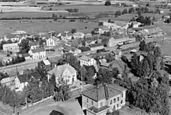 View of the village (1951) | |
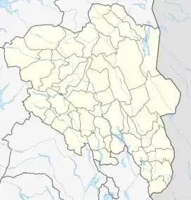 Løten Location of the village  Løten Løten (Norway) | |
| Coordinates: 60°49′10″N 11°20′32″E / 60.81941°N 11.34209°E | |
| Country | Norway |
| Region | Eastern Norway |
| County | Innlandet |
| District | Hedmarken |
| Municipality | Løten Municipality |
| Area | |
| • Total | 1.88 km2 (0.73 sq mi) |
| Elevation | 228 m (748 ft) |
| Population (2021)[1] | |
| • Total | 2,754 |
| • Density | 1,466/km2 (3,800/sq mi) |
| Time zone | UTC+01:00 (CET) |
| • Summer (DST) | UTC+02:00 (CEST) |
| Post Code | 2340 Løten |
Løten is the administrative centre of Løten Municipality in Innlandet county, Norway. The village is located about 15 kilometres (9.3 mi) east of the town of Hamar. The village of Ådalsbruk lies about 4 kilometres (2.5 mi) to the south and the village of Brenneriroa lies about 2 kilometres (1.2 mi) to the northwest. Løten Church lies about 1 kilometre (0.62 mi) northwest of the village.[3]
The 1.88-square-kilometre (460-acre) village has a population (2021) of 2,754 and a population density of 1,466 inhabitants per square kilometre (3,800/sq mi).[1]
The Rørosbanen railway line runs through the village, stopping at the Løten Station. The Norwegian National Road 3 passes by the north side of the village.
Media gallery


References
- 1 2 3 Statistisk sentralbyrå (1 January 2021). "Urban settlements. Population and area, by municipality".
- ↑ "Løten, Løten (Innlandet)". yr.no. Retrieved 27 March 2022.
- ↑ Mæhlum, Lars, ed. (1 November 2021). "Løten (tettsted)". Store norske leksikon (in Norwegian). Kunnskapsforlaget. Retrieved 27 March 2022.
This article is issued from Wikipedia. The text is licensed under Creative Commons - Attribution - Sharealike. Additional terms may apply for the media files.