Lachapelle-sous-Rougemont | |
|---|---|
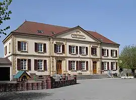 Town hall-school | |
.svg.png.webp) Coat of arms | |
Location of Lachapelle-sous-Rougemont | |
 Lachapelle-sous-Rougemont 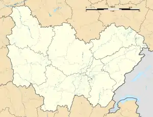 Lachapelle-sous-Rougemont | |
| Coordinates: 47°42′47″N 7°00′59″E / 47.7131°N 7.0164°E | |
| Country | France |
| Region | Bourgogne-Franche-Comté |
| Department | Territoire de Belfort |
| Arrondissement | Belfort |
| Canton | Giromagny |
| Intercommunality | Vosges du Sud |
| Government | |
| • Mayor (2020–2026) | Éric Parrot[1] |
| Area 1 | 4.89 km2 (1.89 sq mi) |
| Population | 569 |
| • Density | 120/km2 (300/sq mi) |
| Time zone | UTC+01:00 (CET) |
| • Summer (DST) | UTC+02:00 (CEST) |
| INSEE/Postal code | 90058 /90360 |
| Elevation | 372–403 m (1,220–1,322 ft) |
| 1 French Land Register data, which excludes lakes, ponds, glaciers > 1 km2 (0.386 sq mi or 247 acres) and river estuaries. | |
Lachapelle-sous-Rougemont (French pronunciation: [laʃapɛl su ʁuʒmɔ̃], literally Lachapelle under Rougemont) is a commune in the Territoire de Belfort department in Bourgogne-Franche-Comté in northeastern France.
See also
Wikimedia Commons has media related to Lachapelle-sous-Rougemont.
References
- ↑ "Répertoire national des élus: les maires" (in French). data.gouv.fr, Plateforme ouverte des données publiques françaises. 13 September 2022.
- ↑ "Populations légales 2021". The National Institute of Statistics and Economic Studies. 28 December 2023.
This article is issued from Wikipedia. The text is licensed under Creative Commons - Attribution - Sharealike. Additional terms may apply for the media files.