| Lake Menghough | |
|---|---|
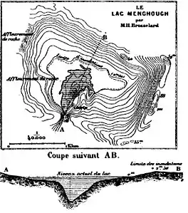
 Map and cross-section by Henri Brosselard-Faidherbe | |
 Lake Menghough | |
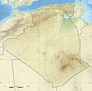
| Coordinates | Approx. 26°22′57″N 8°49′03″E / 26.382478°N 8.817555°E |
| Type | Lake |
| Basin countries | Algeria |
Lake Menghough was an intermittent lake in the southeast of Algeria. It is described in the account of the first Flatters expedition, which reached the lake in April 1880. Other European visitors found the lake dry or filled depending on rainfall.
Location
The lake was to the east of the Tassili n'Ajjer.[1] The lake is 120 kilometres (75 mi) from Ghat, Libya.[2] The Flatters expedition came to it when travelling southeast along the well-wooded Irhararer valley (Oued i-n-Karaha?) to the point where it joined the Tijoujelt valley, not far from Tajenout.[lower-alpha 1] At this point, the surplus waters of the Tijoujelt during the rainy season empty into lake Menghough.[4] Lake Menghough is located on the northern shore of the Wadi of the same name.[5] The sheet of water is enclosed in a sort of circle surrounded by high dunes beside the Wadi Tidjoudjelt, an affluent of the Wadi Igharghar.[6]
Flatters expedition
The first Flatters expedition left Biskra early in February 1880 and travelled south by Touggourt, Ouargla, Aïn-el-Taïba and Temassinin. The expedition encamped on shores of Lake Menghough on 16 April 1880.[7] At this time the lake was about 1,100 by 100 yards (1,006 by 91 m), with creeks fringed by tamarisk and flowering plants on its southern side. The other shores were low and clayey.[4] They found yellow-eyed Clarias lazera (African sharptooth catfish) in the lake.[1] The expedition members swam in the lake, and caught five fish, the longest of which was 2 feet (0.61 m) long.[8] Near Lake Menghough in the Ighargharen valley the expedition found two double stone tombs surrounded by a circular wall about 9 metres (30 ft) in diameter, with a gap in the wall towards the east. The Tuaregs could not supply any information about the tombs.[9] With provisions running short and the local people showing hostility, Flatters decided to return by the same route.[7]
A member of the Flatters expedition reported that:
The water was sweet, but slightly brackish at the western part, where the deposits brought down by the Tijoujelt form shallows, on which the saline ingredients of the water are concentrated by the action of the sun. A small island in it was frequented by snipe, herons, and other semi-aquatic birds; and many fish were observed in its waters, including Clarias lazera, Cuv. and Val., a Nile species found elsewhere in the Tuareg region by Duveyrier. After some difficulty, the bottom of the lake was reached and measured; soon after leaving the banks, the sides reached 13 to 16 feet, and towards the middle narrow transverse, fissures 25 feet in depth were found. This latter circumstance, added to the fact of the temperature rapidly diminishing from the sides, and the assurance of the Tuaregs that the lake was never dry, though of varying size according to season, led the author to the conclusion that there is a permanent source of supply; otherwise it would probably be classed with the neighbouring temporary lakes (Saghen) found north of Tajenout, on Duveyrier's route from Ghadames to Rhat.[4]
Later expeditions
The French explorer Gaston Méry visited the lake in 1893 after a long period of drought, and found it completely dry.[5] Méry was the first French explorer to visit the region since the massacre of the second Flatters expedition. He and Guilloux were accompanied by five local Algerians. At Lake Menghough Méry met with some of the Kel Ajjer chiefs. [10]
Antoine Bernard d'Attanoux found water in the lake when he visited it in March 1894. This was in a rainy period, and the rains in the preceding weeks had overwhelmed the wadis and turned the plain into a vast swamp. The expedition had to avoid the valley floors and travel with some difficulty by the higher land.[5] Attanoux could not approach the lake very closely, and set up his camp a few kilometers to the southwest at the mouth of the Wadi Timatouiet.[5] Attanoux noted that Colonel Flatters had thought the lake was fed by an underground source, and that this was plausible despite the lake drying up, since there was no permanent water table in the region and the source could therefore have dried up.[5] He reported that the Ighargharen valley with its sand-clay soils seemed to have great potential for agriculture, particularly cereals. Boreholes would be enough to find water from the rains that sometimes fall in several consecutive years. However, the nomadic Tuaregs did not practice agriculture.[11]
Notes
- ↑ Geonames places Hassi Tadjenout, a well, at 26°29′00″N 8°48′00″E / 26.48333°N 8.8°E.[3]
- 1 2 Asher 2008, PT92.
- ↑ Wahl 1896, p. 113.
- ↑ Hassi Tadjenout – Geonames.
- 1 2 3 Royal Geographical Society 1881, p. 503.
- 1 2 3 4 5 Attanoux 1894, p. 131.
- ↑ Lanier 1887, p. 408.
- 1 2 Grandjean.
- ↑ Porch 2005, p. 109.
- ↑ Revue Archeologique 1885, p. 90.
- ↑ Nouvelles géographiques 1893, p. 58.
- ↑ Attanoux 1894, p. 130.
Sources
- Asher, Michael (2008-05-17), Death in the Sahara: The Lords of the Desert and the Timbuktu Railway Expedition Massacre, Skyhorse Publishing, ISBN 978-1-5107-2016-9, retrieved 2017-09-24
- Attanoux (1894), "Bulletin Mensuel (7 Mai 1894)", Afrique explorée et civilisée: journal mensuel (in French), J. Sandoz., retrieved 2017-09-25
- Grandjean, Charles, "Flatters", Imago Mundi (in French), retrieved 2017-09-03
- "Hassi Tadjenout", Geonames, retrieved 2017-09-25
- Lanier, Lucien (1887), Choix de lectures de géographie (in French), Belin, retrieved 2017-09-25
- Nouvelles géographiques (in French), Librairie Hachette et Cie., 1893, retrieved 2017-09-25
- Porch, Douglas (2005-06-22), The Conquest of the Sahara: A History, Farrar, Straus and Giroux, ISBN 978-1-4299-2209-8, retrieved 2017-09-24
- Royal Geographical Society (1881), Proceedings of the Royal Geographical Society and Monthly Record of Geography, Edward Stanford, retrieved 2017-09-24
- Revue Archeologique (1885), The American Journal of Archaeology and of the History of the Fine Arts, Ginn, retrieved 2017-09-24
- Wahl, Maurice (1896), "La France au Sahara", La France aux colonies (PDF) (in French), Paris: Ancienne Maison Quantin, retrieved 2017-09-25