Larkinsville, Alabama | |
|---|---|
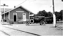
 Larkinsville Railroad Depot, 1920s | |
 Larkinsville  Larkinsville | |
| Coordinates: 34°41′23″N 86°7′36″W / 34.68972°N 86.12667°W | |
| Country | United States |
| State | Alabama |
| County | Jackson |
| Time zone | UTC-6 (Central (CST)) |
| • Summer (DST) | UTC-5 (CDT) |
| ZIP code | 35766 |
| Area code(s) | 256 & 938 |
| GNIS feature ID | 121399 |
Larkinsville is a historic village and populated place in Jackson County, Alabama, United States. Founded in 1828 by David Larkin,[1] it was incorporated into the nearby City of Scottsboro in the late 1960s.[2] In 1895, Larkinsville had a population of 216.[3] As late as 1940, the population was 320 according to the U.S. Census.[4] The historic Blue Spring Cemetery is located one mile southwest of the old village center.
History
David Larkin, third son born to a family of pioneers in Tennessee, established a trading post at Larkin's Landing on the Tennessee River near Goosepond Island shortly after Alabama gained statehood in 1819.[5] In the 1820s, he established a plantation of 32,000 acres[6] two miles west of present-day Scottsboro, and the village of Larkinsville developed around it. A post office was established in 1830, with David Larkin as postmaster, and Larkinsville became the most populous town in Jackson County up until the Civil War.[7] The first overland route through Larkinsville, now known as the Old Stage Road or County Road 30[8] ran from Huntland, Tennessee, across Cumberland Mountain and ended at Larkin's Landing. In 1850 the Memphis and Charleston railroad extended its line through Jackson County; David Larkin, as a railroad commissioner, established a station at Larkinsville.[9]
In the Civil War, Company K, the Larkinsville Guards, was organized in Larkinsville and served with the 4th Alabama Regiment under Captain A.C. Murray.[10] The war devastated Larkinsville, as it did most of North Alabama. On June 30, 1862, shortly after the fall of Huntsville, the Tenth Wisconsin regiment occupied Larkinsville.[11] As a stop along the strategically important railroad, Larkinsville would be occupied by Union forces for the remainder of the war, including the 13th Wisconsin,[12] the 10th Iowa,[13] the 116th Illinois,[14] and the 101st U.S. Colored Regiment.[15]
The postwar establishment of the county seat at Scottsboro began a gradual movement of people and business away from Larkinsville.[16] The railroad kept the village alive into the 1930s, but Alabama State Road 35 and U.S. 72, the main east-west highways in Jackson county, bypassed Larkinsville entirely. [17] Today the formerly thriving village remains a tiny rural community.[18]
References
- ↑ Kennamer, John Robert, Sr., History of Jackson County Alabama, Jackson County Historical Association, Scottsboro, Alabama 1935 (reprinted 1993), page 164
- ↑ "Notification Service | Post Offices". www.postalhistory.com. Retrieved 2023-09-04.
- ↑ "Larkinsville (Jackson County, AL): Nearby in 1890s". roadsidethoughts.com. Retrieved 2023-09-04.
- ↑ Sixteenth Census of the United States, 1940, United States of America, Bureau of the Census, Washington, D.C.: National Archives and Records Administration, 1940
- ↑ Kennamer, p. 23
- ↑ 1850 Agricultural Census - Jackson Co., AL, Alabama Department of Archives and History,http://files.usgwarchives.net/al/jackson/census/1850/1850jacksonag.txt
- ↑ Kennamer, page 164
- ↑ Kennamer, page 26
- ↑ "The Democrat 21 Mar 1850, page 1". Newspapers.com. Retrieved 2023-09-04.
- ↑ Larkin, Priscilla (2021). Miss Priscilla Larkin: The Civil War Diary of a Southern Belle, January 1-December 21, 1862. Malbuff.
- ↑ Miss Priscilla Larkin, 6/30/1862
- ↑ "Union - Wisconsin Infantry (Part 1)". www.civilwararchive.com. Retrieved 2023-09-04.
- ↑ "Union - Iowa Infantry (Part 2)". www.civilwararchive.com. Retrieved 2023-09-04.
- ↑ "Default | eHISTORY". ehistory.osu.edu. Retrieved 2023-09-04.
- ↑ "101st Regiment U.S. Colored Infantry". www.buffalosoldier.net. Retrieved 2023-09-04.
- ↑ Kennamer, page 165
- ↑ Milepost Maps (Map) (1999 ed.). Alabama Department of Transportation
- ↑ Larkinsville United Methodist Church,photo and caption,https://www.flickr.com/photos/auvet/451426598