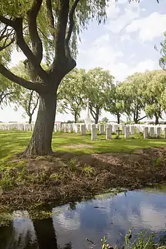
| Le Trou Aid Post Cemetery | |
|---|---|
| Commonwealth War Graves Commission | |
 Le Trou Aid Post | |
| For Allied war dead of World War I | |
| Established | October 1914 |
| Location | 50°37′26″N 02°49′35″E / 50.62389°N 2.82639°E near |
| Designed by | Sir Herbert Baker |
| Total burials | 350+ |
Unknowns | 200+ |
| Burials by nation | |
| Statistics source: Commonwealth War Graves Commission[1] | |
The Le Trou Aid Post Cemetery is a World War I cemetery located in the commune of Fleurbaix, in the Pas-de-Calais departement of France, about 3 kilometres (1.9 mi) south of the village of Fleurbaix on the D175 road (rue de Pétillon).[1]
British soldiers of the 19th Infantry Brigade made the earliest burials at the site in October 1914 during the First Battle of Ypres.[2] By the end of the war, the cemetery contained 123 graves.[2] This number nearly tripled after a postwar consolidation of war burial sites, when Le Trou Aid Post was expanded by the architect Sir Herbert Baker.[2]
Described as one of Baker's most sentimental works,[3] the rural site is surrounded by a narrow moat and sheltered by a grove of weeping willows. Visitors approach over a footbridge and enter through a delicate cottage-style gateway.[3]
The cemetery contains more than 350 graves, and over two hundred are unidentified.[2] The dead represent the battlefields of Ypres, Le Maisnil (October 1914), Aubers Ridge (May 1915), Loos (September–October 1915), and Fromelles (July 1916).[2]
See also
References
- 1 2 "Le Trou Aid Post Cemetery, Fleurbaix". Cwgc.org. Commonwealth War Graves Commission. Retrieved 29 December 2013..
- 1 2 3 4 5 "CWGC – Cemetery Details". Cwgc.org. Commonwealth War Graves Commission. Retrieved 29 December 2013.
- 1 2 Geurst, Jeroen (2010). Cemeteries of the Great War by Sir Edwin Lutyens. Rotterdam: 010 Publ. p. 70. ISBN 9789064507151.
External links
- Le Trou Aid Post Cemetery at Find a Grave
 Media related to Le Trou Aid Post Cemetery, Fleurbaix at Wikimedia Commons