The following outline is provided as an overview of and topical guide to the Philippines:
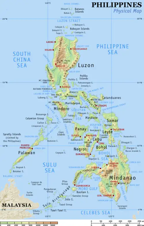
Philippines – archipelagic country in Southeast Asia. In the western Pacific Ocean, it consists of 7,641 islands which are broadly categorized in three main geographical divisions from north to south: Luzon, Visayas, and Mindanao. The Philippines is bounded by the South China Sea to the west, the Philippine Sea to the east, and the Celebes Sea to the south. It shares maritime borders with Taiwan to the north, Japan to the northeast, Palau to the east and southeast, Indonesia to the south, Malaysia to the southwest, Vietnam to the west, and China to the northwest.
General reference

- Pronunciation: /ˈfɪləpiːnz/ ⓘ
- Abbreviations: PH or PHL
- Common English country name: Philippines, the Philippines
- Official English country name: Republic of the Philippines
- Common endonyms: Philippines, Pilipinas, Pinas (informal)
- Official endonym: Republic of the Philippines, Republika ng Pilipinas
- Common exonyms: the Philippines, the Philippine Islands (archaic)
- Adjectivals: Philippine, Filipino
- Demonyms: Filipino (masculine or neutral; among others), Filipina (feminine)
- Etymology: named after Philip II of Spain
- International rankings of the Philippines
- ISO country codes: PH, PHL, 608
- ISO region codes: See ISO 3166-2:PH
- Internet country code top-level domain: .ph
Geography of the Philippines

- The Philippines is: an archipelagic megadiverse island country
- Location:
- Northern Hemisphere and Eastern Hemisphere
- Time zone: Philippine Standard Time (UTC+08)
- Extreme points of the Philippines
- North: Mavulis (Y'Ami) Island, Itbayat, Batanes 21°7′18.41″N 121°56′48.79″E / 21.1217806°N 121.9468861°E
- South: Frances Reef, Sitangkai, Tawi-Tawi 4°24′53.84″N 119°14′50.71″E / 4.4149556°N 119.2474194°E
- East: Pusan Point, Caraga, Davao Oriental 7°17′19.80″N 126°36′18.16″E / 7.2888333°N 126.6050444°E
- West: Balabac Great Reef, Balabac, Palawan 7°54′36.35″N 116°53′16.64″E / 7.9100972°N 116.8879556°E
- Subject to territorial dispute: Thitu Island, Kalayaan, Palawan 11°3′N 114°17′E / 11.050°N 114.283°E
- High: Mount Apo 2,954 m (9,692 ft)
- Low: Philippine Sea and South China Sea 0 m (0 ft)
- Land boundaries: none
- Coastline: 36,289 km (22,549 mi) – 5th longest coastline
- Population: 109,035,343 (2020 census) 13th most populous country
- Area: 300,000 km2 (120,000 sq mi) – 72nd most extensive country
- Atlas of the Philippines
- Cities in the Philippines by population
Environment of the Philippines

- Beaches of the Philippines
- Climate of the Philippines
- Environmental issues in the Philippines
- Ecoregions in the Philippines
- Renewable energy in the Philippines
- Geology of the Philippines
- Headlands of the Philippines
- National Parks of the Philippines
- Protected areas of the Philippines
- Wildlife of the Philippines
Geographic features of the Philippines
- Bays of the Philippines
- Islands of the Philippines
- Island groups of the Philippines
- Lakes in the Philippines
- Mountains of the Philippines
- Rivers of the Philippines
- Waterfalls of the Philippines
- World Heritage Sites in the Philippines
- Peninsulas of the Philippines
Island groups of the Philippines
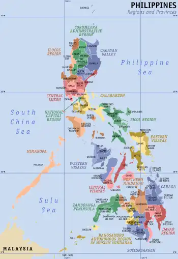
Administrative divisions of the Philippines

Regions of the Philippines
Provinces of the Philippines
- Abra
- Agusan del Norte
- Agusan del Sur
- Aklan
- Albay
- Antique
- Apayao
- Aurora
- Basilan
- Bataan
- Batanes
- Batangas
- Benguet
- Biliran
- Bohol
- Bukidnon
- Bulacan
- Cagayan
- Camarines Norte
- Camarines Sur
- Camiguin
- Capiz
- Catanduanes
- Cavite
- Cebu
- Cotabato
- Davao de Oro
- Davao del Norte
- Davao del Sur
- Davao Occidental
- Davao Oriental
- Dinagat Islands
- Eastern Samar
- Guimaras
- Ifugao
- Ilocos Norte
- Ilocos Sur
- Iloilo
- Isabela
- Kalinga
- La Union
- Laguna
- Lanao del Norte
- Lanao del Sur
- Leyte
- Maguindanao del Norte
- Maguindanao del Sur
- Marinduque
- Masbate
- Misamis Occidental
- Misamis Oriental
- Mountain Province
- Negros Occidental
- Negros Oriental
- Northern Samar
- Nueva Ecija
- Nueva Vizcaya
- Occidental Mindoro
- Oriental Mindoro
- Palawan
- Pampanga
- Pangasinan
- Quezon
- Quirino
- Rizal
- Romblon
- Samar
- Sarangani
- Siquijor
- Sorsogon
- South Cotabato
- Southern Leyte
- Sultan Kudarat
- Sulu
- Surigao del Norte
- Surigao del Sur
- Tarlac
- Tawi-Tawi
- Zambales
- Zamboanga del Norte
- Zamboanga del Sur
- Zamboanga Sibugay
Cities of the Philippines
- Alaminos
- Angeles
- Antipolo
- Bacolod
- Bacoor
- Bago
- Baguio
- Bais
- Balanga
- Batac
- Batangas City
- Bayawan
- Baybay
- Bayugan
- Biñan
- Bislig
- Bogo
- Borongan
- Butuan
- Cabadbaran
- Cabanatuan
- Cabuyao
- Cadiz
- Cagayan de Oro
- Calaca
- Calamba
- Calapan
- Calbayog
- Caloocan
- Candon
- Canlaon
- Carcar
- Catbalogan
- Cauayan
- Cavite City
- Cebu City
- Cotabato City
- Dagupan
- Danao
- Dapitan
- Dasmariñas
- Davao City
- Digos
- Dipolog
- Dumaguete
- El Salvador
- Escalante
- Gapan
- General Santos
- General Trias
- Gingoog
- Guihulngan
- Himamaylan
- Iligan
- Iloilo City
- Imus
- Iriga
- Isabela
- Kabankalan
- Kidapawan
- Koronadal
- La Carlota
- Lamitan
- Laoag
- Lapu-Lapu
- Las Piñas
- Legazpi
- Ligao
- Lipa
- Lucena
- Maasin
- Mabalacat
- Makati
- Malabon
- Malaybalay
- Malolos
- Mati
- Mandaluyong
- Mandaue
- Manila
- Marawi
- Marikina
- Masbate City
- Meycauayan
- Muñoz
- Muntinlupa
- Naga, Camarines Sur
- Naga, Cebu
- Navotas
- Olongapo
- Ormoc
- Oroquieta
- Ozamiz
- Pagadian
- Palayan
- Panabo
- Parañaque
- Pasay
- Pasig
- Passi
- Puerto Princesa
- Quezon City
- Roxas
- Sagay
- Samal
- San Carlos, Negros Occidental
- San Carlos, Pangasinan
- San Fernando, La Union
- San Fernando, Pampanga
- San Jose
- San Jose del Monte
- San Juan
- San Pablo
- San Pedro
- Santa Rosa
- Santiago
- Santo Tomas
- Silay
- Sipalay
- Sorsogon City
- Surigao City
- Tabaco
- Tacloban
- Tacurong
- Tagaytay
- Tagbilaran
- Taguig
- Tagum
- Talisay, Cebu
- Talisay, Negros Occidental
- Tanauan
- Tandag
- Tangub
- Tanjay
- Tarlac City
- Tayabas
- Toledo
- Trece Martires
- Tuguegarao
- Urdaneta
- Valencia
- Valenzuela
- Victorias
- Vigan
- Zamboanga City
Municipalities of the Philippines
Barangays of the Philippines
Demographics of the Philippines
Climate of the Philippines
History of the Philippines
Period-coverage
Presidents of the Philippines
- Emilio Aguinaldo: 1899–1901
- Manuel L. Quezon: 1935–1944
- Jose P. Laurel: 1943–1945
- Sergio Osmeña: 1944–1946
- Manuel Roxas: 1946–1948
- Elpidio Quirino: 1948–1953
- Ramon Magsaysay: 1953–1957
- Carlos P. Garcia: 1957–1961
- Diosdado Macapagal: 1961–1965
- Ferdinand Marcos: 1965–1986
- Corazon Aquino: 1986–1992
- Fidel V. Ramos: 1992–1998
- Joseph Estrada: 1998–2001
- Gloria Macapagal Arroyo: 2001–2010
- Benigno Aquino III: 2010–2016
- Rodrigo Duterte: 2016–2022
- Bongbong Marcos: 2022–present
Government and politics of the Philippines
- Form of government: Unitary presidential constitutional republic
- Capital of the Philippines: Manila[lower-alpha 1]
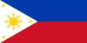
- Flag of the Philippines
- Political parties in the Philippines
- Elections in the Philippines
- List of political parties in the Philippines
National government of the Philippines
Legislative branch
Executive branch
Executive departments
- Department of Agrarian Reform
- Department of Agriculture
- Department of Budget and Management
- Department of Education
- Department of Energy
- Department of Environment and Natural Resources
- Department of Finance
- Department of Foreign Affairs
- Department of Health
- Department of Human Settlements and Urban Development
- Department of Information and Communications Technology
- Department of Justice
- Department of Labor and Employment
- Department of Migrant Workers
- Department of National Defense
- Department of Public Works and Highways
- Department of Science and Technology
- Department of Social Welfare and Development
- Department of the Interior and Local Government
- Department of Tourism
- Department of Trade and Industry
- Department of Transportation
Commissions
- Civil Service Commission
- Commission on Appointments
- Commission on Audit
- Commission on Elections
- Commission on Filipino Migrant Workers
- Commission on Filipinos Overseas
- Commission on Higher Education
- Commission on Human Rights
- Constitutional Commission
- Consultative Commission on Charter Change
- Komisyon sa Wikang Filipino
- National Commission for Culture and the Arts
- National Commission on Indigenous Peoples
- National Historical Commission of the Philippines
- National Telecommunications Commission
- National Youth Commission
- Philippine Commission for the Urban Poor
- Philippine Commission on Justice and Peace
- Philippine Insurance Commission
- Philippine Sports Commission
- Population Commission
- Professional Regulation Commission
- Securities and Exchange Commission
Judicial branch
Local government in the Philippines
Foreign relations of the Philippines
International organization membership
Military of the Philippines
Intelligence agencies
Law of the Philippines
- Adoption in the Philippines
- Cannabis in the Philippines
- Capital punishment in the Philippines
- Census in the Philippines
- Censorship in the Philippines
- Child-related laws
- Constitution of the Philippines
- Copyright law in the Philippines
- Crime in the Philippines (Revised Penal Code)
- Human rights in the Philippines
- Abortion in the Philippines
- Censorship in the Philippines
- Freedom of association in the Philippines
- Freedom of religion in the Philippines
- Freedom of speech in the Philippines
- Freedom of the press in the Philippines
- Gambling in the Philippines
- LGBT rights in the Philippines
- Marriage and union in the Philippines
- Prostitution in the Philippines
- Right to keep and bear arms
- Smoking in the Philippines
- Law enforcement in the Philippines
- Local ordinance
- Speed limits in the Philippines
- Taxation in the Philippines
Culture of the Philippines
- Architecture of the Philippines
- Cuisine of the Philippines
- Charities in the Philippines
- Ethnic groups in the Philippines
- Festivals in the Philippines
- Media in the Philippines
- Museums in the Philippines
- Mythology of the Philippines
- National symbols of the Philippines
- Public holidays in the Philippines
- Records of the Philippines
- Religion in the Philippines
- List of World Heritage Sites in the Philippines
Art in the Philippines
- Art Deco theaters of the Philippines
- Cinema of the Philippines
- Literature of the Philippines
- National Artist of the Philippines
- Television in the Philippines
Music of the Philippines
Languages of the Philippines
Sports in the Philippines
- Baseball in the Philippines
- Basketball in the Philippines
- Maharlika Pilipinas Basketball League
- Metropolitan Basketball Association
- Mindanao Visayas Basketball Association
- National Basketball Conference
- Philippine Basketball Association
- Philippine Basketball League
- Philippine men's national basketball team
- Philippine women's national basketball team
- Samahang Basketbol ng Pilipinas
- United Regional Basketball League
- Boxing in the Philippines
- Football in the Philippines
- Filipino Martial Arts
- Philippines at the Olympics
- Rugby in the Philippines
- Other
- Eskrima or Escrima
- Mano Mano
- National Collegiate Athletic Association
- Palarong Pambansa
- Panantukan
- National Athletic Association of Schools, Colleges and Universities
- Philippine Sports Association for the Differently Abled—National Paralympic Committee of the Philippines
- Philippine Sports Commission
- Triathlon Association of the Philippines
- University Athletic Association of the Philippines
Education in the Philippines
Economy and infrastructure of the Philippines
- Economic rank, by nominal GDP (2007): 46th (forty-sixth)
- Agriculture in the Philippines
- Banking in the Philippines
- Companies of the Philippines
- Currency of Philippines: Peso *
- Fiscal policy of the Philippines
- Mining in the Philippines
- Shopping malls in the Philippines
- Philippine Government Securities
- Philippine Stock Exchange
- Taxation in the Philippines
- Tourism in the Philippines
- Water supply and sanitation in the Philippines
Energy in the Philippines
- Electricity distribution
- Energy policy of the Philippines
- Oil industry in the Philippines
- Power plants in the Philippines
Transportation in the Philippines
- Airports in the Philippines
- Lighthouses in the Philippines
- Rail transportation in the Philippines
- Vehicular transport in the Philippines
- Road system in the Philippines
- Vehicles in the Philippines
See also
Notes
- ↑ While Manila proper is designated as the nation's capital, the whole of Metro Manila is designated as the National Capital Region (NCR), and the seat of government, hence the name of a region.[1] Many national government institutions aside from Malacañang Palace and some agencies/institutions are located within the NCR.
References
- ↑ "Presidential Decree No. 940, s. 1976". Manila: Malacanang. Retrieved April 4, 2015.
External links
 Wikibooks in Philippine languages
Philippine Wikipedias (Incubator Status)
- Aklan language (incubator:Wp/akl)
- Miraya Bikol language (incubator:Wp/rbl)
- Pandan Bikol language (incubator:Wp/cts)
- Rinconada Bikol language (incubator:Wp/bto)
- Capiznon language (incubator:Wp/cps)
- Hiligaynon language (incubator:Wp/hil)
- Kinaray-a language (incubator:Wp/krj)
- Maranao language (incubator:Wp/mrw)
- Tausug language (incubator:Wp/tsg)
Philippine Wikimedia (Incubator Status)
![]() Wikimedia Atlas of the Philippines
Wikimedia Atlas of the Philippines
- Official
- Official website of the Philippine Government – Portal to governmental sites
- Maps
- Other
- WOW Philippines Tourism Ad
- Around Philippines Photos
- Washington Post: How the Philippines Sees America
 Philippines travel guide from Wikivoyage
- BBC Country Profile on the Philippines
- CIA World Factbook: Philippines
- U.S. Country Studies: Philippines
- Philippines Daily Photos
- Origins of the Filipinos and Their Languages by Wilhelm G. Solheim II (PDF)
- History of the Philippine Islands in many volumes, from Project Gutenberg (and indexed under Emma Helen Blair, the general editor)
- USAID country health statistical report: Philippines (May 2008)


.jpg.webp)