Lorentzweiler
Luerenzweiler | |
|---|---|
 | |
 Coat of arms | |
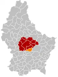 Map of Luxembourg with Lorentzweiler highlighted in orange, and the canton in dark red | |
| Coordinates: 49°42′N 6°09′E / 49.7°N 6.15°E | |
| Country | |
| Canton | Mersch |
| Area | |
| • Total | 17.45 km2 (6.74 sq mi) |
| • Rank | 65th of 102 |
| Highest elevation | 436 m (1,430 ft) |
| • Rank | 25th of 102 |
| Lowest elevation | 219 m (719 ft) |
| • Rank | 35th of 102 |
| Population (2023) | |
| • Total | 4,521 |
| • Rank | 41st of 102 |
| • Density | 260/km2 (670/sq mi) |
| • Rank | 33rd of 102 |
| Time zone | UTC+1 (CET) |
| • Summer (DST) | UTC+2 (CEST) |
| LAU 2 | LU0000408 |
| Website | lorentzweiler.lu |
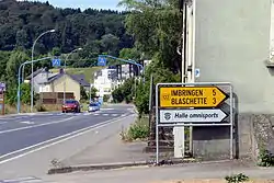
Lorentzweiler (Luxembourgish: Luerenzweiler) is a commune and small town in central Luxembourg, in the canton of Mersch. It is situated on the river Alzette.
As of 2023, the town of Lorentzweiler, which lies in the centre of the commune, has a population of 1483. Other towns within the commune include Blaschette, Bofferdange, and Helmdange, Hunsdorf.
Population
Notable people
- Joseph Wohlfart (1920–2000), a Luxembourgian politician, served on the communal council of Lorentzweiler for 20 years from 1950.
- Emile Haag (born 1942), a Luxembourgish historian, trade unionist and former principal of the Athénée de Luxembourg.
- Prince Guillaume, Hereditary Grand Duke of Luxembourg (born 1981), the heir apparent to the crown of Luxembourg, attended primary school in Lorentzweiler.
- Prince Félix of Luxembourg (born 1984), also attended primary school at Lorentzweiler.
References
- ↑ "Population par canton et commune". statistiques.public.lu. Retrieved 11 January 2022.
External links
 Media related to Lorentzweiler at Wikimedia Commons
 | ||
This article is issued from Wikipedia. The text is licensed under Creative Commons - Attribution - Sharealike. Additional terms may apply for the media files.