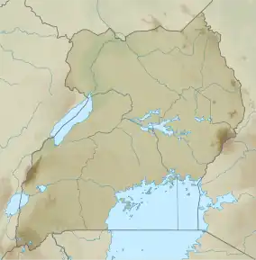
| Lutembe Bay | |
|---|---|
 Lutembe Bay | |
| Coordinates | 0°09′15″N 32°34′05″E / 0.1541°N 32.5681°E |
| Basin countries | Uganda |
| Surface area | 800 hectares (3.1 sq mi) |
| Surface elevation | 1,130 metres (3,710 ft) |
| Official name | Lutembe Bay Wetland System |
| Designated | 15 September 2006 |
| Reference no. | 1637[1] |
Lutembe Bay is a wetland on the edge of Lake Victoria.
Conservation
Lutumbe Bay is one of Uganda's 33 Important Bird Areas and since 2006 a Ramsar-listed wetland of international importance.[2] The bay is notable for its population of as many as 1.5m white-winged tern.[3]
in 2013 a portion of the wetland was illegally filled with soil by the flower export giant Rosebud Ltd.[4]
References
- ↑ "Lutembe Bay Wetland System". Ramsar Sites Information Service. Retrieved 25 April 2018.
- ↑ Ramsar Convention on Wetlands. "The Annotated Ramsar List: Uganda". Archived from the original on 7 January 2013. Retrieved 28 June 2012.
- ↑ Byaruhanga, Achilles; Kasoma, Pantaleon; Pomeroy, Derek. "Uganda" (PDF). Country Profiles. BirdLife International. Retrieved 16 August 2013.
- ↑ Muhumuza, Rodney (15 August 2013). "Uganda loses wetland to rose farming business". Miami Herald. AP. Retrieved 16 August 2013.
This article is issued from Wikipedia. The text is licensed under Creative Commons - Attribution - Sharealike. Additional terms may apply for the media files.