Lutogniewice | |
|---|---|
Village | |
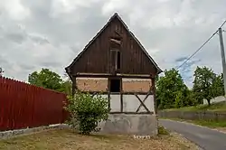 Half-timbered house | |
 Lutogniewice  Lutogniewice | |
| Coordinates: 51°00′29″N 14°58′3″E / 51.00806°N 14.96750°E | |
| Country | |
| Voivodeship | Lower Silesian |
| County | Zgorzelec |
| Gmina | Bogatynia |
| Population | 218 |
Lutogniewice [lutɔɡɲɛˈvit͡sɛ] is a village in the administrative district of Gmina Bogatynia, within Zgorzelec County, Lower Silesian Voivodeship, in south-western Poland, close to the Czech and German borders.[1]
It lies approximately 11 kilometres (7 mi) north of Bogatynia, 17 km (11 mi) south of Zgorzelec, and 146 km (91 mi) west of the regional capital Wrocław.
Gallery
.jpg.webp) Barn
Barn.jpg.webp) Wayside cross
Wayside cross Bus stop
References
Wikimedia Commons has media related to Lutogniewice.
| Town and seat |  | |
|---|---|---|
| Villages | ||
This article is issued from Wikipedia. The text is licensed under Creative Commons - Attribution - Sharealike. Additional terms may apply for the media files.