Mal
Māl | |
|---|---|
Community Development Block | |
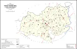 Map of Mal CD block | |
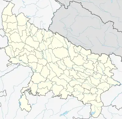 Mal Location in Uttar Pradesh, India 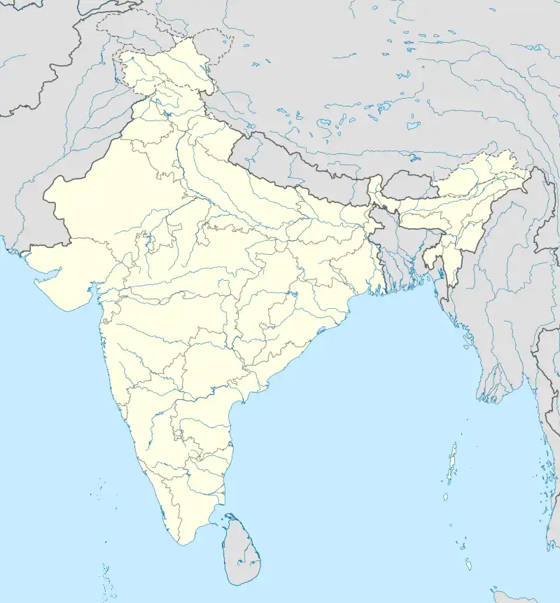 Mal Mal (India) | |
| Coordinates: 27°01′18″N 80°44′09″E / 27.02156°N 80.73584°E[1] | |
| Country | |
| State | Uttar Pradesh |
| District | Lucknow |
| Area | |
| • Total | 2.619 km2 (1.011 sq mi) |
| Elevation | 130 m (430 ft) |
| Population (2011)[2] | |
| • Total | 6,429 |
| • Density | 2,500/km2 (6,400/sq mi) |
| Languages | |
| • Official | Hindi |
| Time zone | UTC+5:30 (IST) |
| PIN | 226104 |
| Vehicle registration | UP32 |
Mal, also spelled Mall, is a village and corresponding community development block in Lucknow district of Uttar Pradesh, India.[2] It is part of the tehsil of Malihabad.[2] As of 2011, the population of Mal was 6,429, in 1,199 households, while the population of Mal block was 170,962, in 31,429 households.[2]
History
Mal was historically the seat of a tribe of Gaharwar Rajputs, whose family tradition states that they came from Manda-Bijaipur near Varanasi under one Rai Paitawan, a brother of the ruler of Varanasi.[3] The story goes that Rai Paitawan had gone on a pilgrimage to Nimkhar, in what is now Sitapur district, and after encountering a good omen on the way back, he decided to stay in this area.[3] He drove out the ruling Jhojhas from their forts at Mal and Ant to become ruler himself.[3] The Gaharwars' territory later became divided among seven estates: Mal, Atari, Salinagar, Amlauli, Masira, Hamirpur, and Nabipanah.[3] By the turn of the 20th century, the Gaharwars' influence had declined, and they only owned about a quarter of the village lands in Mal.[3] The remainder of the lands were held by Pandit Bakht Narain.[3]
At the turn of the century, Mal had a population of 1,775, and it had a marketplace called Ramnarainganj after its founder, Pandit Ram Narain (Bakht Narain's father), which hosted markets twice a week, on Thursdays and Sundays.[3] There was also a weekly cattle market.[3] Three fairs were held here annually: the Athon fair during the month of Chait, the Mahabir fair in Jeth, and the Janamashtami fair in Bhadon.[3] Mal's soil was described as highly fertile, and wheat was the main crop grown.[3] Irrigation was provided by wells, tanks, and also some from the Jhingi nala, which flows to the east of the village.[3] There were at the time two Hindu temples, one mosque, and also the mausoleum of a saint named Gulmir Shah.[3]
Villages
Mal block comprises the following 87 villages:[2]
| Village name | Total land area (hectares) | Population (in 2011) |
|---|---|---|
| Vahir | 246.6 | 1,244 |
| Ahindar | 391.7 | 3,876 |
| Umraval | 606.5 | 3,380 |
| Rahata | 251.9 | 1,886 |
| Siswara | 294.4 | 2,011 |
| Gorava Baravki | 177.4 | 2,131 |
| Saspan | 1,180.1 | 8,378 |
| Kamaluddin Nagar | 52 | 486 |
| Gopal Pur | 219.2 | 1,601 |
| Tilan | 556.2 | 2,289 |
| Jamolia | 581.8 | 4,628 |
| Gahndo | 650.9 | 4,957 |
| Thari | 755.3 | 5,175 |
| Barkhorava | 295.9 | 1,717 |
| Muriyara | 413.6 | 2,975 |
| Kharsara | 743.4 | 3,557 |
| Saidapur | 309.8 | 2,562 |
| Auntgarhi Saura | 643.5 | 4,532 |
| Visunpur | 141.6 | 145 |
| Karend | 292.7 | 2,467 |
| Para Bhadrahi | 487.2 | 4,451 |
| Navbasta | 106.7 | 781 |
| Shahmau | 114.2 | 1,117 |
| Atari | 338.8 | 2,308 |
| Roodan Khera | 164.1 | 1,021 |
| Jindana | 180.8 | 1,050 |
| Mawai Khurd | 294 | 1,556 |
| Basant Pur | 372.6 | 2,883 |
| Bhelam Pur | 45.4 | 491 |
| Birpur | 391.6 | 1,885 |
| Devari Ganja | 191.8 | 1,073 |
| Akbar Pur | 181.8 | 1,024 |
| Shankar Pur | 221.1 | 1,906 |
| Godhan | 107.6 | 157 |
| Saleh Nagar | 534.1 | 3,962 |
| Raipur | 246 | 1,343 |
| Badiya | 412.4 | 3,083 |
| Tikari Kala | 262.8 | 1,155 |
| Kamalpur Lodhaura | 361.3 | 1,086 |
| Didhara | 87.9 | 782 |
| Pipari Kurakhar | 298.8 | 2,443 |
| Bahraura | 225 | 1,813 |
| Pakara | 206.4 | 1,626 |
| Devari Bharat | 246.8 | 1,258 |
| Shahpurgorava | 234 | 1,370 |
| Madwana | 770.4 | 4,393 |
| Ataria, Lucknow | 207.9 | 810 |
| Manjhi Nikrojpur | 500.6 | 2,484 |
| Majhauva | 234.4 | 1,016 |
| Danaur | 233.2 | 1,506 |
| Sultanpur | 92.3 | 337 |
| Aumau | 369 | 2,245 |
| Khakhara | 118.1 | 447 |
| Kolava Bhanaura | 562.2 | 2,136 |
| Adampur | 106.9 | 756 |
| Garhthamma | 120.7 | 541 |
| Latifpur | 116.6 | 969 |
| Gauraiya | 189.8 | 974 |
| Jagdishpur Bujurg | 104.6 | 903 |
| Patauna | 209.1 | 1,786 |
| Sarthara | 208.7 | 1,736 |
| Keraura | 105.2 | 1,438 |
| Amlauli | 139.4 | 626 |
| Peer Nagar | 159.7 | 1,064 |
| Gumsena | 158.4 | 1,257 |
| Ranipara | 306 | 1,844 |
| Narayanpur | 318.2 | 1,285 |
| Ram Nagar | 234.1 | 2,259 |
| Naibasti Bhithaura | 369 | 2,112 |
| Sukka Khera | 165 | 999 |
| Chandwara | 112.7 | 1,209 |
| Bhanwar | 75.9 | 238 |
| Mal (block headquarters) | 261.9 | 6,429 |
| Naru | 40.2 | 183 |
| Vidhishyama | 102.3 | 566 |
| Ant | 142.3 | 1,138 |
| Masirha Ratan | 283.3 | 3,196 |
| Gagan Barauli | 102.6 | 565 |
| Masirha Hamir | 365.4 | 2,279 |
| Saibasi | 193.9 | 1,392 |
| Hasanapur | 514.3 | 3,913 |
| Devari Danda | 76.3 | 943 |
| Nabi Panah | 573.3 | 5,136 |
| Ibrahimpur | 48.7 | 354 |
| Bhanpur | 63.6 | 995 |
| Dhakhava | 444.5 | 4,133 |
| Dautpur | 68.7 | 749 |
References
- 1 2 "Geonames.org. Māl". Retrieved 19 March 2021.
- 1 2 3 4 5 6 "Census of India 2011: Uttar Pradesh District Census Handbook - Lucknow, Part A (Village and Town Directory)". Census 2011 India. pp. 28–67, 76–93, 278–292. Retrieved 19 March 2021.
- 1 2 3 4 5 6 7 8 9 10 11 12 Nevill, H.R. (1904). Lucknow - A Gazetteer. Allahabad: Government Press. pp. 234–5. Retrieved 19 March 2021.